
Fact Sheets And Publications

Selecting a Drone for Crop Scouting
Updated March 2025 | Written by: Jarrod O. Miller, Extension Agronomist, Carvel Research and Education Center
Commercial Drone Market
The drone market targets many different customers, including agricultural professionals. Drone photography at 200-400 feet has the potential to uncover in-season production issues that scouting may miss, such as nutrient deficiencies, pest damage, or irrigation problems. However, the cost of a drone can vary widely, and without experience, choosing the best option is probably difficult for most farmers and consultants. University of Delaware Cooperative Extension has some suggestions for early adopters.
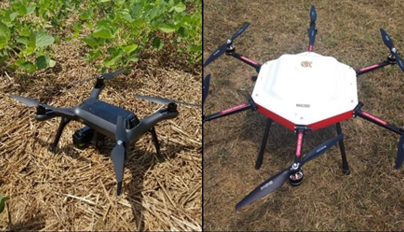
1. Choose a Quadcopter
Rotary drones with four propellers (known as quadcopters) are the most typical drone sold. Compared to drones that mimic airplanes, quadcopters are easier to launch, land, and maneuver. Any rotary drone with more than four propellers is meant to carry a heavier load; these larger drones are a better choice for advanced users (Figure 1).

Not All Drones Come with a Controller
Some drones can also be maneuvered with an app on your phone, so the manufacturer may not include a hand-held controller. Based on experience at UD, hand-held controllers (Figure 2) allow better flight maneuverability than a cell phone application.
A handheld controller will have joysticks to maneuver the drone and possibly have buttons to allow the operator to take photos or request the drone fly back to the takeoff spot. Controllers may also connect to your cellphone or tablet to take images. If you find a cheaper version of the drone online, be careful to make sure it still comes with a controller (Figure 2).
Does it Come with a Camera?
It may seem obvious that a drone would be equipped with some type of camera, but a picture on a website may be misleading. Check to make sure that a camera is included with the drone package, or you may have to purchase the camera separately at an added cost. It will be difficult to scout crops without a camera. For some drones, the camera is integrated into the drone and cannot be removed, while other drones may have a gimbal or fixed camera mount.
Quality becomes important depending on the end user's goals. A scout may prefer a higher-quality camera to share photos with customers. However, many high-quality cameras are designed for video production, which may not be necessary for crop scouting. You do not need a multispectral camera to scout crops, so do not waste your money.
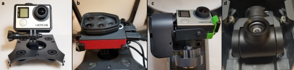
Gimbals are Optional, but Helpful
A gimbal allows for movement of the camera to scan a field left to right, front to back, and straight down. With a gimbal, the camera can be moved while the quadcopter hovers in a stationary position or during flight. We recommended purchasing a drone where the camera moves independently from the drone with a gimbal. Drones that are more expensive may already have a camera/gimbal combination (Figure 3d), while others will require you to purchase a gimbal separately (Figure 3c).
Does it Connect to a Phone or Tablet?
Scouting will be more productive if the camera is sending images or live feed directly to your cell phone or tablet. While cellphone connectivity may not be listed as a feature, a photo of the controller with a cellphone attached is a good indicator that they will connect (Figure 4).
For your cellphone to properly connect to the drone, there must be an associated phone application. Check the specifications for software (as a downloadable app) to fly the drone from the manufacturer or a third party. Many popular drone flight apps for android or apple devices can work with several manufacturers.
What are the Safety Features?
The drone should come with a global positioning system GPS, which can assist with finding the drone during an emergency landing, or facilitate a function called return to home (RTH). For RTH, the drone will return to the takeoff point with the push of a button if the takeoff point was marked with GPS.

A drone should also engage the RTH function if contact with the controller is lost or the battery is dying.
Obstacle avoidance is important for RTH, and it will be up to the drone pilot to make sure the path is clear. However, some drones may also come with infrared sensors that can help avoid larger obstacles, such as trees or homes. It is not recommended to rely on these sensors alone; use common sense when engaging RTH.
While not necessarily a safety feature, check and see how the drone will operate under different weather conditions. The top concern is winds, which can vary considerably over the course of the day. We experience particularly high wind speeds during spring, and a stable drone would be helpful instead of planning around low wind conditions.
Signal Range
Many drones connect to controllers through WiFi signals and can lose contact when flown too far. Some drones may only maintain signal 200 feet from the takeoff point, while others may reach between 3,000 feet to 5 miles. Look to the listed technical specifications before purchasing; if none are listed be wary. Drones must be kept within line of site, so a 5-mile signal range is unrealistic. However, agronomists scouting fields should expect to need at least a half-mile (3,000 feet) to get the most out of scouting. In one direction, 3,000 feet could potentially cover 120 acres (Figure 5). An additional issue may arise in populated areas, where home WiFi signals may override and cut off contact with your drone. If the drone has a RTH function, it may automatically engage when signal is lost, which should reduce the issue of WiFi interference.
Battery Life
Signal distance and battery life will determine how many acres can be scouted during a single flight. The estimated battery life of any drone is probably longer than a pilot will achieve. Drones with more propellers, cameras, and WiFi will drain batteries faster. While many quadcopters may advertise 25 to 30-minute flight times, the reality may be closer to 15 minutes. If you include return time for a safe landing, it may leave about 10 minutes for scouting. This is also another reason to have RTH as an option. When the low battery is indicated, selecting RTH can be a safe way to bring the drone back the fastest. Practice will make any drone operator more efficient when scouting fields and allow for increased productivity.

Spare Parts?
It appears that propellers may be one of the cheaper spare parts, as many drones will come with at least four extra propellers. Batteries are costlier. Ideally a drone comes with at least three batteries but be sure to check the accessories that come with the drone. Here are some extra parts to look for:
Controller
Propellers
Batteries
Carrying Case
Android or Apple Connection cords
Look to Spend between $800 to $1200
From our experience at UD, if you want to have all the features listed above, expect to pay at least $800. There are drones that cost $400 or less that may suit your needs, but we have not tested them. Any drone that costs less than $100 is probably good for honing your flying skills around the house, but these cheap units will not perform when scouting crops. Anything over $2,000 is considered either professional or research grade and is not necessary for the crop scout. We suggest avoiding any drone that costs more than $10,000, as the return on investment does not currently exist. At UD, we cannot endorse any particular drone. However, we have worked with the 3DR Solo, Parrot Disco Pro Ag, and several DJI products (Phantom3, Phantom4, Mavic Air, Mavic Pro, and Spark), each with its own benefits and drawbacks.
Enough people have purchased drones that you can ask opinions on the quality and issues they have experienced. It is never a good idea to spend a lot of money on a drone you know nothing about, particularly considering the above issues. Check reviews and opinions before you make a purchase.
Peer Reviewed By:
Mark VanGessel, Professor and Extension Specialist, Plant and Soil Science Department, University of Delaware
Amy L. Shober, Associate Professor and Extension Specialist, Plant and Soil Science Department, University of Delaware
UD Cooperative Extension
This institution is an equal opportunity provider.
In accordance with Federal law and U.S. Department of Agriculture policy, Cooperative Extension is prohibited from discriminating on the basis of race, color, national origin, sex, age, or disability.