
Sea Level Rise
Sea Level Rise
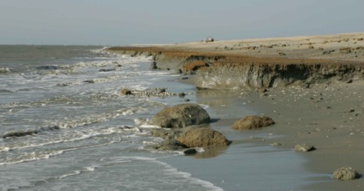
All across the world, sea levels are expected to rise in response to climate change. However, for the state of Delaware, sea level rise is especially concerning due to the state’s flat topography, low mean elevation, and heavy reliance on large scale investments in coastal activities, like tourism and infrastructure development. With the rate of sea level rise only expected to increase over the next century, Delaware will become susceptible to a series of environmental phenomena, including increased coastal inundation and erosion, accelerated saltwater contamination of ground and surface water supplies, and loss of critical coastal habitats unless proper mitigative strategies are implemented.
Sea Level Rise: Planning Scenarios for Delaware: youtube.com/watch?v=xNa7OLaW7K0
Global Mean Sea Level Rise and Relative Sea Level Rise
Global mean sea level rise (GMSLR) refers to the increase in sea-surface height across all of the world’s oceans, while relative sea level rise (RSLR) refers to the increase in sea-surface height relative to the land at a specific location.
Global changes in sea level are primarily attributed to the following two factors:
1. Land-based ice melt
2. Thermal expansion of seawater.[i]
Global Mean Sea Level Rise
Melting Ice Sheets and Mountain Glaciers
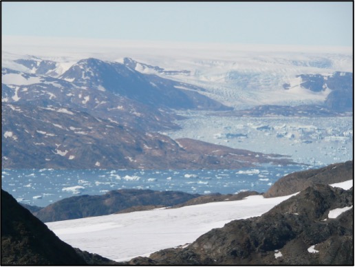
As air temperatures rise, the melting of continental ice sheets and mountain glaciers can add significant amounts of freshwater into the oceans. According to the National Snow & Ice Data Center, an ice sheet consists of glacial land ice that extends for more than 50,000 square kilometers (20,000 square miles).[ii] On Earth today, two main ice sheets exist: the Greenland and Antarctic ice sheets. Together, they contain more than 99 percent of the freshwater ice on the planet.[iii]
Though both the melting of the Antarctic and Greenland ice sheets have contributed to GMSLR over the past century, the Greenland ice sheet has had a larger impact on global sea levels than the Antarctic.[i] Based on data from the Intergovernmental Panel on Climate Change’s (IPCC) Sixth Assessment Report, between 1992-2020, Greenland likely lost 4,890 ± 460 gigaton of ice and contributed 13.5 ± 1.3 millimeters to GMSLR.[ii] Over the same period, the Antarctic ice sheet likely lost 2,670 ± 530 gigaton of ice, but only contributed 7.4 ± 1.5 mm to GMSLR.[iii] If the entire Greenland ice sheet were to melt, scientists estimate that global sea levels would rise approximately 24 feet (7.4 meters).[iv]
In addition to ice sheet melt, melting from mountain glaciers has also made significant contributions to rises in global sea levels. These distinct masses of ice cover an area of approximately 439,000 miles globally and have the potential to raise global sea levels by 1.3 feet (0.4 meters).[v] Currently, the glaciers that have had the largest impact on global sea levels include those located in Alaska and the Arctic, as well as the melting ice fields in the Patagonia region of South America.[vi]
Thermal Expansion
While increasing atmospheric temperatures can cause ice sheets and glaciers to melt, they can also increase the temperature of the oceans’ seawater, causing it to expand as its density decreases. Referred to as thermal expansion, this natural climatic process occurs throughout all of the world’s oceans and has helped explain 50% of global sea level rise between 1971-2018.[vii]
Relative Sea Level Rise
Though, on average, global sea levels continue to rise, it is important to note that sea levels in coastal regions and communities are not all rising at the same rates.4 Since 1920, global mean sea level (GMSL) has risen by approximately 17 centimeters, while relative sea level (RSL) averaged along the contiguous United States has risen by 28 centimeters over the same period.4 In Delaware alone, according to tide gauge data collected in Lewes, sea levels have risen more than 13 inches since 1900 (0.13 inches per year), a rate that is nearly double the global rate of sea level rise (0.07 inches per year).[viii]
Though the state’s sea levels will continue to be influenced by global contributors, like those mentioned above, processes specific to the Mid-Atlantic region, such as geologic land subsidence and changing ocean circulation patterns, will also play a large role in increasing sea-surface height across Delaware’s coastlines.[i]
Glacial Isostatic Adjustment and Subsidence
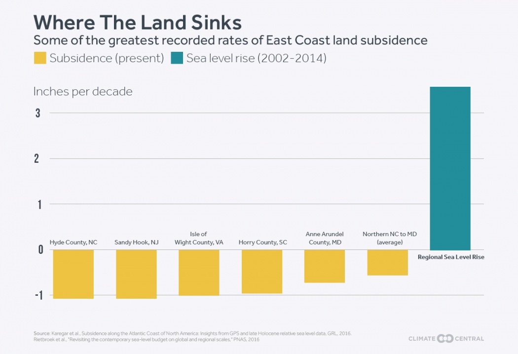
As sea levels continue to rise, Delaware, along with the rest of the Mid-Atlantic states, have actually begun to sink, thanks to two related geologic processes: glacial isostatic adjustment (GIA) and subsidence. During the last Ice Age, an incredibly large mass of ice, known as the Laurentide ice sheet, covered much of North America.1 With thicknesses of up to 2.5 miles (4 km) in some areas, portions of land caught beneath the ice sheet became compressed due to its immense weight, while land located on the outskirts of the sheet experienced uplift.1 Over time, however, as atmospheric temperatures have risen, much of the ice sheet has melted away, triggering a reverse adjustment in land level.1 Put simply, due to the retreat of the ice sheet, areas that were once compressed are now slowly returning to their previous level, while areas that experienced uplift are beginning to sink back down. This entire process is known as glacial isostatic adjustment (GIA) with the gradual sinking of the land referred to as subsidence. Since Delaware is located close to the southern limit of the now-collapsed Laurentide ice sheet, over the last 10,000 years, the state has experienced a general rise in relative sea level as its land area has continued to gradually sink.1 In addition to Delaware, other places along the East Coast of the United States, like the Chesapeake Bay, based on estimates from the Geological Society of America, will sink as much as half a foot over the next century due to subsidence caused by past glacial activity.[i]
Changing Ocean Circulation Patterns
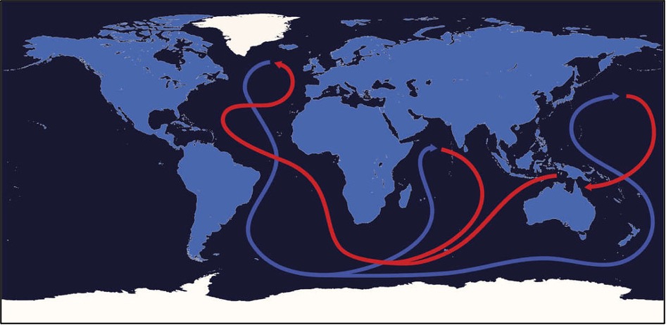
According to numerous climate models, a collection of ocean currents in the Atlantic Ocean known as the Atlantic Meridional Overturning Circulation (AMOC) are expected to weaken as ocean waters continue to warm and expand.[ii] The AMOC resembles an oceanic conveyor belt that transports warmer waters northward to higher latitude regions. There, the water comes into contact with colder air temperatures and stronger winds, causing it to become both colder and denser.[iii] As the colder water sinks into the deep ocean, it is quickly cycled back southward at depth, completing the circulation.[iv]
Within the scientific community, much research has been conducted on how the AMOC is being affected by rising air and ocean temperatures. Climate models that simulate conditions under a warming future climate suggest that a weakening of the AMOC would reduce the amount of heat brought to the North Atlantic, and instead concentrate it along the eastern and southern coasts of North America.[v] As a result of this redistribution, scientists believe that the east coast of the United States, along with most of the Atlantic basin, could experience accelerated rates of sea level rise.
Sea Level Rise Impacts on Delaware
Since Delaware is affected by multiple factors that contribute to both GMSLR and RSLR, it, along with the entire Mid-Atlantic region, has become known as a “hotspot” for sea level rise.1 As a result, the state has already begun to feel the effects of sea level rise across a wide variety of areas, including agriculture, natural resources, infrastructure, and human health.
Note: Each impact description provided in the boxes below has been adapted from both the 2021 Delaware Climate Action Plan, as well as the 2017 Delaware Sea-Level Rise Technical Committee’s “Recommendation of Sea-Level Rise Planning Scenarios for Delaware” report. Please view these impacts in the context provided by the primary source documents listed below:
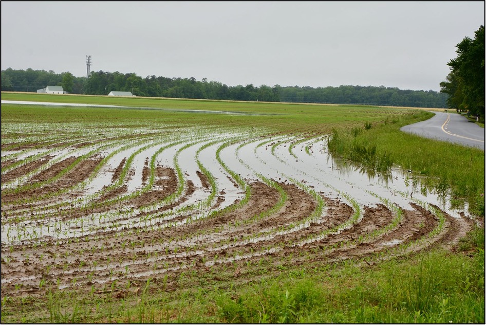
Under natural conditions, the movement of freshwater towards the sea prevents saltwater from encroaching on stores of underground freshwater, known as aquifers.[xvii] Howerver, as sea levels rise, the boundary between underground salt and freshwater begins to move inland, enabling saltwater to intrude into underground water supplies.[xviii] This process, commonly referred to as a saltwater intrusion can heavily degrade the quality of underground freshwater used for human consumption and irrigation.[xi] For example, if an irrigation well is located near the boundary, the groundwater will not be usable for irrigation, thereby decresing crop yields while raising farmers' costs to access usable water. Additionally, if saltwater floods onto agricultural fields, the health of the soil and its ability to support crops could be completely undermined by the increased salt content (even after being exposed temporarily!).[xi]
For more information about how sea level rise is impacting and will continue to impact Delaware agriculture, please see the Salt Impacted Agricultural Lands factsheet.
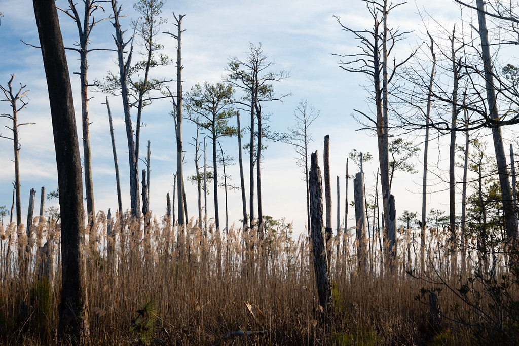
Delaware contains 73,000 acres of tidal wetlands, each of which provide numerous benefits to both humans and native biodiversity, including habitat for commercially important species, sediment and pollutant removal, and protection from storm surges and flooding.1 Unfortunately, if these wetlands are unable to increase their elevation or migrate inland, projections indicate that with just 1.5 feet of sea level rise, 97% of them could become inundated.[xi]
In addition to wetlands, wildlife areas, state parks, and forests are also at risk from sea level rise. Though coastal forests, for example, are comprised of trees that stand far above any encroaching floodwaters, if the water table gets too high, the roots of said trees will drown, causing them to perish. This process leads to the formation of new, lifeless ecosystems known as ghost forests. Ghost forests form when saltwater enters into a freshwater system, typically a tidal wetland or coastal forest that is often marked by specific vegetation and tree species, like the Atlantic white cedar.[xix] Though research is still being done to see how the loss of coastal forests will affect the climate, one thing remains certain: the Atlantic Coast has quickly become a hotspot for ghost forest formation. According to recent research from the Virginia Institute of Marine Sciences, over the past century, the death of coastal forests has accelerated every decade and is now occurring three times faster.[xx] In the Chesapeake Bay region alone, more than 150 square miles of coastal forests have already been converted into ghost forests and marshland.[xxi]
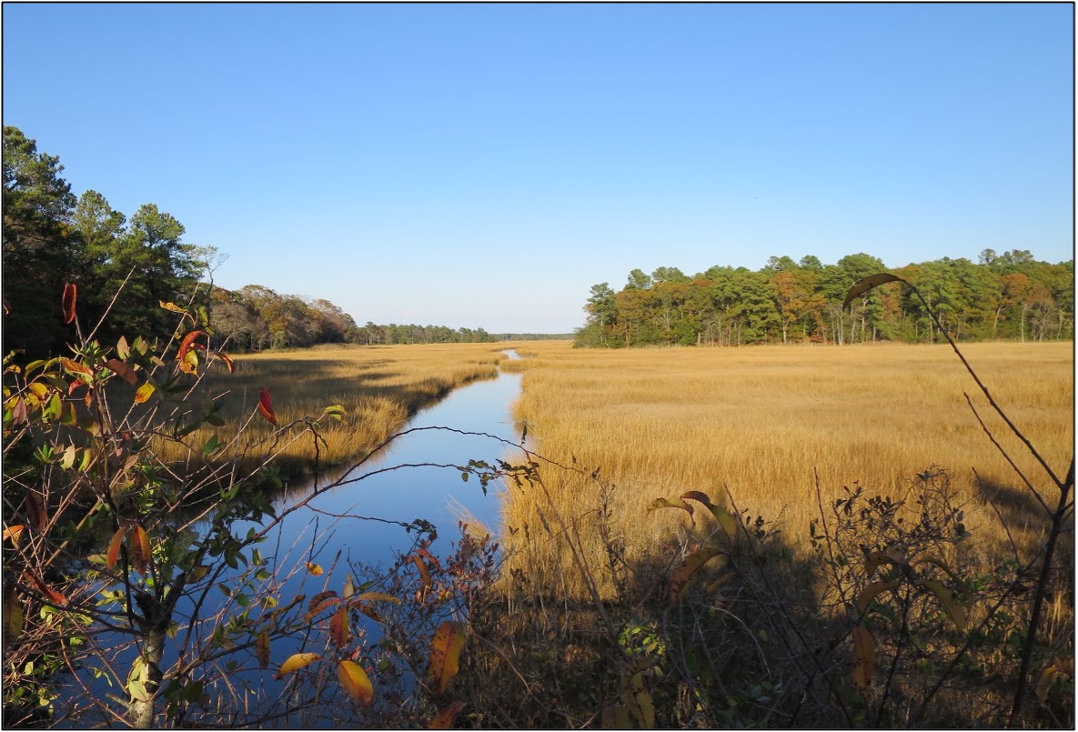
Since most of Delaware’s drinking water comes from underground water supplies, saltwater intrusions sparked by rising sea levels can greatly increase the salt content of groundwater, making these vital sources of water potentially unusable by the Delaware public.[xi] Above ground, sea level rise can also affect Delaware’s freshwater river and stream networks, which provide drinking water and habitat for recreational and commercial fish species, like American shad and striped bass, who rely on freshwater rivers for spawning.[xi]
With regards to vegetation and plant life, saltwater intrusions and increased flooding can force many different plant species to move farther inland, thus allowing for saltmarsh plants to move in and take their place.[xxii] This process is known as saltmarsh migration. Though salt marshes are among some of the most productive ecosystems on the planet, there exists growing concern as to whether they can withstand the accelerated sea level rise created by climate change. In Delaware, numerous wetland studies conducted by the DNREC Wetland Monitoring and Assessment Program indicate that common reed (Phragmites australis) are colonizing flooded areas before saltmarsh plants can even migrate in.[xxiii]
One Minute Wetlands - Free Ranging Marshes: youtube.com/watch?v=RgBBJEkszRQ
Public Infrastructure
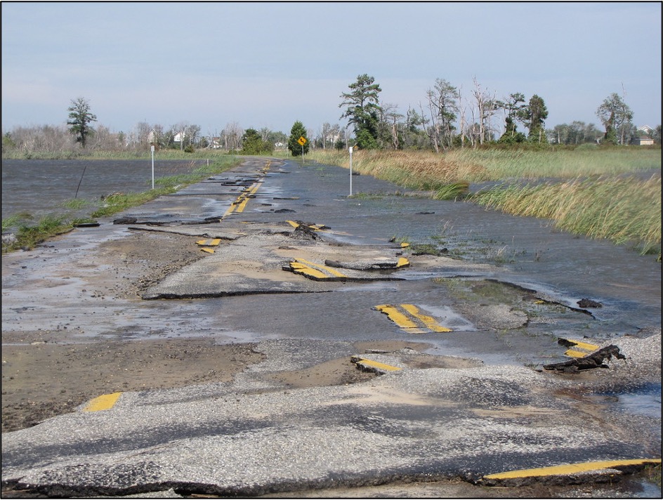
Sea level rise impacts to infrastructure can be particularly problematic when combined with heavy rainstorm events, making access to roads and evacuation routes even more difficult when they are needed most. A 5-foot rise in sea levels could inundate 5% of the state’s roads and bridges and 6% of evacuation routes, thus affecting affect both the ability of people to travel safely across the state and the provision of essential goods and emergency services.[xi] Additionally, sea level rise can also impact the state’s wastewater infrastructure. Since many wastewater treatment facilities are located along waterways, sea level rise could increase their susceptibility to flooding.[xi] Likewise, since many of the state’s electrical sub-stations and transmission lines are located in areas at risk to sea level rise, many of these facilities can be damaged by flooding and become inaccessible during storm events, increasing the risk of lengthy power outages during storm events.[xi]
Private Property
According to a 2018 study conducted by the Union for Concerned Scientists, within the next 10-15 years, 147,000 coastal homes and 7,000 commercial properties are at risk of being inundated an average of 26 times a year, or more.[xxiv] Due to chronic inundation, homeowners risk being unable to capitalize on one of their greatest assets as their homes are subjected to continuous flood damage, making them less desirable (and potentially unsellable) on the real estate market.[xxv] Even if homes are located just outside of the inundation zone, their close proximity to other at-risk properties could cause them to experience significant declines in property value.
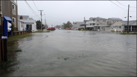
In coastal areas, health and injury risks are directly related to an individual or community’s exposure and vulnerability to climate hazards, like sea level rise. While coastal flooding and storm surges can increase risks of drowning and injury, the excess dampness left behind by floodwaters can accelerate indoor mold growth, which serves as a trigger for numerous respiratory issues.[xxvi] Similarly, saltwater intrusions into groundwater basins and drinking wells are linked to increased risks of hypertension, as well as a wide variety of vector-borne diseases.9
In addition to the direct human health impacts associated with sea level rise, it is important to also recognize that, due to certain social and economic inequities, some individuals and communities will become more susceptible to the impacts of sea level rise than others. Many low-income individuals lack proper disaster insurance, as well as access to resources that aid in recuperating from property loss.[xxvii] Consequently, this places them at greater risk for destabilization and displacement from flooding. For residents that are forced to leave their homes, relocation may prove to be stressful if it becomes difficult to find alternative places to live that are affordable and provide access to jobs, schools, and other amenities.[xxviii]
Adaptation Strategies
Since it is evident that both natural ecosystems and man-made infrastructure are impacted by the changes occurring in our oceans, the implementation of adaptation strategies that limit vulnerability to sea level rise is essential. With respect to sea level rise, the Delaware Sea Level Rise Advisory Committee recommends the four following adaptation strategies:
- Avoid building in the coastal zone by limiting new development in these areas through easements, setbacks, and transfers of development rights
- Accommodate for sea level rise by raising homes and structures along the coast and managing drainage with green infrastructure like rain gardens, bioswales (linear grassed or vegetated channels for conveying stormwater), and naturally designed water retention ponds
- Protect coastal lands from floodwater damage and inundation by constructing bulkheads, dikes, and living shorelines and carrying out beach nourishment projects
- Retreat and relocate coastal developments away from the shoreline through managed retreat, rolling easements, and land acquisition in order to protect them from inundation
In addition to these four adaptation strategies, other recommendations for how to personally respond to sea level rise, as well as how to build up the state’s ability to adapt to sea level rise, are outlined in the 2013 document “Preparing for Tomorrow’s High Tide: Recommendations for Adapting to Sea Level Rise in Delaware.” Prepared by the Sea Level Rise Advisory Committee and by staff of the Delaware Coastal Programs section of the Delaware Department of Natural Resources and Environmental Control (DNREC), the document is intended to assist government agencies, businesses, and individuals alike prepare and respond to the risks posed by sea level rise. Additionally, the document also provides a set of guiding principles for consideration by those choosing to implement the adaptation measures outlined.
See both the full document and executive summary below to learn more about sea level rise in Delaware, as well as what adaptive measures can be taken to decrease the state’s susceptibility to sea level rise in the future.
Delaware Sea Level Rise Resources
- Coastal Inundation Maps for Delaware – an easy-to-use sea level rise map developed by scientists at DNREC Coastal Programs and the University of Delaware that shows the possible inundation of Delaware land based on three sea level rise scenarios
- Surging Seas Risk Finder – an interactive toolkit, developed by Climate Central, that aims to provide citizens, communities, and policymakers with easily accessible, science-based, local information in order to inform responses to rising sea levels and coastal flooding
- Recommendation of Sea-Level Rise Planning Scenarios for Delaware Technical Report – prepared by the Delaware Sea-Level Rise Technical Committee, this report outlines the impacts that sea level rise will have, and is already having, on Delaware infrastructure, tourism, and tidal wetlands, as well as which framework the state should use
- Delaware Sea Grant – an education and outreach arm of the UD College of Earth, Ocean, and Environment, Delaware Sea Grant helps communities use, manage, and conserve the state’s coastal resources by prioritizing resilience and fostering environmental stewardship
- Delaware Flood Planning Tool – an interactive online mapping application designed by DNREC that helps citizens make informed decisions about the degree of flood risk for a specific area or property located within Delaware state boundaries
- 2022 Sea Level Rise Technical Report – a technical report created by the Sea Level Rise and Coastal Flood and Tools Interagency Task Force that not only provides the most up-to-date sea level rise projections available for all U.S. states and territories, but also seeks to help communities assess and adapt to changes in average tide heights and height-specific threshold capacities
Author
Wylie Feaster
Environmental Quality Extension Scholar
University of Delaware
Original Publication Date: July 28, 2022
Peer Reviewer
Dr. John Callahan
Climatologist and Visiting Assistant Professor
Department of Geography and Spatial Sciences
University of Delaware
Works Cited
[i] Callahan, John A., Benjamin P. Horton, Daria L. Nikitina, Christopher K. Sommerfield, Thomas E. McKenna, and Danielle Swallow, Recommendation of Sea-Level Rise Planning Scenarios for Delaware: Technical Report, prepared for Delaware Department of Natural Resources and Environmental Control (DNREC) Delaware Coastal Programs (Dover, DE: DNREC Division of Energy and Climate, 2017).
[ii] National Snow & Ice Data Center, “Quick Facts on Ice Sheets,” (Boulder, CO: National Snow and Ice Data Center, 2022).
[iii] Ibid
[iv] Sweet, William V., Benjamin D. Hamlington, Robert E. Kopp, Christopher P. Weaver, Patrick L. Barnard, David Bekaert, Michael Craghan, Gregory Dusek, Thomas Frederikse, Gregory Garner, Ayesha S. Genz, John P. Krasting, Eric Larour, Doug Marcy, John J. Marra, Jayantha Obeysekera, Mark Osler, Matthew Pendleton, Daniel Roman, Lauren Schmied, Will Veatch, Kathleen D. White, and Casey Zuzak, Global and Regional Sea Level Rise Scenarios for the United States: Updated Mean Projections and Extreme Water Level Probabilities Along U.S. Coastlines, (Silver Spring, MD: National Oceanic and Atmospheric Association, 2022).
[v] Fox-Kemper, B., H. T. Hewitt, C. Xiao, G. Aðalgeirsdóttir, S. S. Drijfhout, T. L. Edwards, N. R. Golledge, 10 M. Hemer, R. E. Kopp, G. Krinner, A. Mix, D. Notz, S. Nowicki, I. S. Nurhati, L. Ruiz, J-B. Sallée, A. B. A. Slangen, Y. Yu, “Ocean, Cryosphere and Sea Level Change.” In: Climate Change 2021: The Physical Science Basis. Contribution of Working Group I to the Sixth Assessment Report of the Intergovernmental Panel on Climate Change [Masson-Delmotte, V., P. Zhai, A. Pirani, S. L. Connors, C. Péan, S. Berger, N. 14 Caud, Y. Chen, L. Goldfarb, M. I. Gomis, M. Huang, K. Leitzell, E. Lonnoy, J.B.R. Matthews, T.K. Maycock, T. Waterfield, O. Yelekçi, R. Yu and B. Zhou (eds).] (Cambridge, ENG: Cambridge University Press, 2021).
[vi] Ibid
[vii] Lowe, J.A., Gregory, J.M., Ridley, J., Huybrechts, P., Nicholls, R.J., Collins, M. The role of sea-level rise and the Greenland ice sheet in dangerous climate change: Implications for the stabilisation of climate. In: Schellnhuber, H. J., Cramer, W. P., Nakicenovic, N., Wigley, T. M. L. and Yohe, G. (eds.) Avoiding dangerous climate (Cambridge, ENG: Cambridge University Press, 2006)
[viii] Zemp, M., Huss, M., Thibert, E. et al. “Global glacier mass changes and their contributions to sea-level rise from 1961 to 2016,” Nature 568, 382–386 (2019). https://doi.org/10.1038/s41586-019-1071-0
[ix] IPCC, 2022: Summary for Policymakers [H.-O. Pörtner, D.C. Roberts, E.S. Poloczanska, K. Mintenbeck, M. Tignor, A. Alegría, M. Craig, S. Langsdorf, S. Löschke, V. Möller, A. Okem (eds.)]. In: Climate Change 2022: Impacts, Adaptation, and Vulnerability. Contribution of Working Group II to the Sixth Assessment Report of the Intergovernmental Panel on Climate Change [H.-O. Pörtner, D.C. Roberts, M. Tignor, E.S. Poloczanska, K. Mintenbeck, A. Alegría, M. Craig, S. Langsdorf, S. Löschke, V. Möller, A. Okem, B. Rama (eds.)]. (Cambridge, ENG: Cambridge University Press).
[x] Ibid
[xi] De Mooy, Jennifer, Margaret Pletta, and Ian Yue, Delaware’s Climate Action Plan, (Dover, DE: Delaware Department of Natural Resources and Environmental Control, 2021).
[xii] DeJong, B., Bierman, P., Newell, W., Rittenour, T., Mahan, S., Balco, G., and Rodd, D., “Pleistocene relative sea levels in the Chesapeake Bay region and their implications for the next century,” GSA Today, v.25, no.8 (2015). https://doi.org/10.1130/GSATG223A.1
[xiii] Christopher Piecuch, “Understanding Sea Level Rise,” (Woods Hole, MA: Woods Hole Oceanographic Institute, 2019).
[xiv] Ibid
[xv] Ibid
[xvi] Ibid
[xvii] United States Geological Survey (USGS), “Sal11twater Intrusion,” (Reston, VA: USGS, 2019).
[xviii] Ibid
[xix] Lauria, Maddy, “Ghost forests tell the story,” Delaware News Journal. (Wilmington, DE: Delaware News Journal, 2019).
[xx] Kirwan, Matthew L. and Gedan, Keryn B., “Sea-level driven land conversion and the formation of ghost forests,” Nature Climate Change 9, 450-457 (2019). https://doi.org/10.1038/s41558-019-0488-7
[xxi] Ibid
[xxii] Dorset, Erin, “When Saltwater Intrusion Meets Freshwater Wetlands…”, Wetland Assessments (Dover, DE: DNREC Wetland Monitoring and Assessment Program, 2018).
[xxiii] Ibid
[xxiv] Union of Concerned Scientists, “Underwater: Rising Seas, Chronic Floods, and the Implications for US Coastal Real Estate,” Union of Concerned Scientists (Cambridge, MA: UCS National Headquarters, 2018).
[xxv] Ibid
[xxvi] Public Health Institute, “Sea Level Rise, Climate Change and Health,” Center for Climate Change & Health (Oakland, CA: Center for Climate Change & Health, 2016).
[xxvii] Morello-Frosh,R., Pastor, M., Sadd, J., Shonkoff, S. The climate gap: Inequalities in how climate change hurts Americans & how to close the gap. (Los Angeles, CA: Program for Environmental and Regional Equity, 2009).
[xxviii] Ibid
UD Cooperative Extension
This institution is an equal opportunity provider.
In accordance with Federal law and U.S. Department of Agriculture policy, Cooperative Extension is prohibited from discriminating on the basis of race, color, national origin, sex, age, or disability.
