
Ocean geology
Photos courtesy of Jessica Warren February 19, 2020
UD’s Jessica Warren and her lab group collect rocks and place seismometers on the ocean floor
Before starting graduate school, University of Delaware doctoral student Melinda Bahruth said she never thought she would be on a research vessel or conducting geological research at sea. The Kansas native isn’t afraid to admit that she’s pretty scared of water in general. But Bahruth faced that fear when she travelled with UD associate professor Jessica Warren and members of Warren’s Mantle Processes Group to the Gofar Transform Fault, which is located underwater on the East Pacific Rise, a mid-ocean ridge that runs south from the Gulf of California.
The group spent nearly a month at sea just west of the Galapagos Islands placing seismometers and collecting rock samples.
“There were times when I was on the ship and I was thinking ‘there’s 4,000 meters below me to the seabed, an unimaginable depth,’ and there was no-one out there besides us,” said Bahruth. “It was a very remote part of the ocean, and you don’t see anybody. It was otherworldly, but incredible to experience.”
The research cruise was the first step in a three-year project funded by the National Science Foundation (NSF) and involves three other institutions, with the University of New Hampshire serving as the lead institution on the project.
In addition to Warren and Bahruth, Cecile Prigent, a postdoctoral researcher, and Kuan-Yu Lin, a doctoral student, were also on the research cruise.

Placing seismometers
Warren, who served as the chief scientist on the cruise, said the underlying question the research group wants to understand is how the rocks deform in earthquakes.
“The next step is figuring out what minerals are in the rocks,” said Warren. “A mineral will tell us a lot about the way in which the rocks fail, which can tell us about a slip in the fault, whether it’s a runaway seismic event or whether it’s a creeping event that fractures those rocks.”
With regards to seismic versus creeping events, Warren said that even though the fault experiences repeating earthquakes, this fault is the boundary between two tectonic plates that are moving past each other. Sometimes this generates earthquakes, but most of the time, the rocks move slowly past each other in an aseismic process called creep.
“The earthquake would be the seismic mechanism. But we know what the plate speed is so we can say, ‘Ok, this is the total amount of earthquake that we should see,’ and if we don’t see that, then we say that we have a seismic deficit,” said Warren. “In this case, we think that most of the fault is creeping instead of undergoing these earthquake events.”
One of the main goals towards solving this question was to place 51 seismometers at the Gofar Transform Fault. The fault has steadily predictable earthquakes, with earthquakes of magnitudes five to six on the Richter scale occurring every five to six years.
The researchers wanted to place seismometers in a window of time where they were most likely to record an earthquake event as it happened.
“We requested to put seismometers out for two years to catch that window because we are in the high-probability window, and this is the best it gets,” said Warren.
Next year, another group of researchers will return to collect the seismometers, record their data, change their batteries and return them to the seafloor. They will also put out a new set of seismometers and use an autonomous underwater vehicle to capture images near the seafloor to take high-resolution bathymetry and photo mosaics, as well as record chemical data.
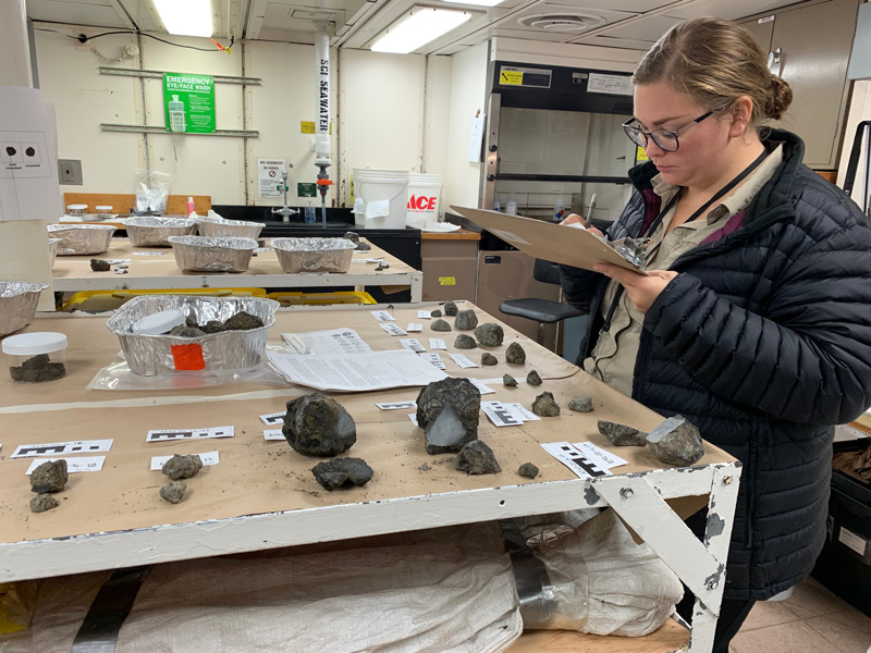
Collecting seafloor rocks
While putting out the seismometers was a big part of the research expedition, the main focus of the UD group was collecting rocks from the fault zone.
“We wanted to investigate the rocks in the fault zone because that’s a major control on how the fault is going to behave,” said Bahruth. “If you have a brittle rock, it could break easily under stress. Whereas, if you have a softer or more malleable rock, it’s possible it could deform without breaking.”
On the ship, dredges ran overnight. The UD group helped to get the dredge equipment overboard and kept records of the locations and the times where they collected certain rocks.
All told, the group collected about 4,500 pounds of rocks.
In some of the dredges, the researchers were getting 400 pounds of rocks that then had to be moved through the lab and processed. The scientists would group rocks by similar features, choose about 50 representative samples per dredge, describe their characteristics in a detailed spreadsheet and then put the rest of the rocks in sacks, weigh them and label them with the dredge number.
Bahruth said that it was great to be able to collect rock samples from specific locations in Gofar because the area has been widely studied seismically, allowing the team to eventually combine what they learn from their samples with what is already known about the region’s earthquakes.
While she has studied rocks in the lab before, this was the first time Bahruth actually collected samples from the seafloor herself.
“Whenever I’m studying ocean floor rock samples, a lot of them were collected in the ’70s and the ’80s,” said Bahruth. “To actually be on the ship and write the sample number and name the rock, it was really awesome. It sounds weird but it was [eye-opening]. I can now place myself in the shoes of the people who did this before me and I have a greater appreciation of the work that went into collecting those rocks.”
Some of the rocks have made their way back to UD where Warren’s group will study them further, but others will go to an open access seafloor repository at Woods Hole Oceanographic Institution in Massachusetts.
Contact Us
Have a UDaily story idea?
Contact us at ocm@udel.edu
Members of the press
Contact us at mediarelations@udel.edu or visit the Media Relations website