
Under the weather
Illustration courtesy of Jeff Buler January 17, 2017
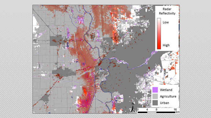
UD researchers use weather radar to track migrating waterfowl, avian influenza
University of Delaware researchers have teamed with the University of California, Davis, and the U.S. Geological Survey (USGS) to use weather radar to identify wetland hotspots used by waterfowl in the Central Valley of California during the winter in an effort to help alert poultry growers in the area about the potential risk of their farms being hit with avian influenza.
At UD, the research is being led by Jeff Buler, assistant professor in the Department of Entomology and Wildlife Ecology in the College of Agriculture and Natural Resources. Buler is being assisted on the project by Jaclyn Smolinsky, a research associate in his laboratory.
Buler’s lab group is processing the radar data for the project and mapping where the waterfowl are on the ground in relation to poultry farms.
The lab at UD is unique in that it’s practically the only active lab using weather radar data to map bird distributions at the ground level.
Using an approach they developed, the researchers are able to identify the birds’ location based on their well synchronized take-off movements.
“In the case of waterfowl, they engage in feeding flights in the winter. They’ll roost in the wetlands during the day and they fly out to agricultural fields — primarily flooded rice fields in California — at night. When they take off and fly into the radar, we get an instant snapshot of where they were on the ground. That’s how we map their distributions,” said Buler, who added that the data is collected 24 hours a day every 5-10 minutes.
By identifying where waterfowl are in the valley, waterfowl biologists from USGS are able to take samples from the birds to look for prevalence of avian influenza, helping to build pathogen risk models for the poultry industry in the region.
Buler said the hope is for the technology now being used in California to one day be utilized in the Delmarva region.
“It’s something that if we do develop it and the poultry industry likes it, we could replicate it here at UD because poultry is certainly a big industry and it’s also an important wintering area for waterfowl here in Delaware,” said Buler.
Another component of the project is that the researchers can compare the data they are collecting to the data they collected during a previous effort in California, looking at waterfowl distributions from 1995 to 2007 that were closely tied to the availability of water.
“Given the recent droughts there, there are concerns about there being enough habitat for waterfowl. An important concern is that when the birds are concentrated in high densities, that’s a scenario for all sorts of other avian diseases like botulism to occur. If there is an outbreak of avian influenza and they’re very concentrated, it can quickly spread,” said Buler.
The research group is also looking at how waterfowl use natural and restored wetlands in the valley in order to examine other questions that are more tied to the biology of the waterfowl.
“We’re interested in looking at how the drought is affecting their populations and also the distributions throughout the valley in addition to being concerned about the spread of avian influenza,” said Buler.
The project was funded by University of California Agriculture and Natural Resources and other collaborators include the California Department of Food and Agriculture, the California Poultry Federation, the Pacific Egg and Poultry Association and Point Blue, an organization that focuses on conservation science.
Contact Us
Have a UDaily story idea?
Contact us at ocm@udel.edu
Members of the press
Contact us at mediarelations@udel.edu or visit the Media Relations website