


ONLINE MAGAZINE ISSN 2150-5128

VOL. 4 / NO. 1 INTERACTIVE PDF ![]()

By teresa messmore College of Earth, Ocean, and Environment

At left is a soil core collected from a salt marsh in Barnegat Bay, New Jersey, in 2009. The soil changes from living roots at the core top to peat and mud at the bottom. The accretion rate, based on radionuclide age dating, is 2.5 millimeters per year.
Marshes reduce storm flooding, filter contaminants out of water and provide habitat for birds, fish and other wildlife. However, these environmentally critical areas have decreased in extent along the coast in recent decades, and UD researchers are working to better understand the factors that affect marsh stability—especially in the face of sea level rise.
“The amount of space that’s available for marshes to survive is getting smaller and smaller,” says Christopher Sommerfield, associate professor of oceanography in the College of Earth, Ocean, and Environment (CEOE).
Tidal marshes exist in low-lying coastal areas between the low and high tide lines. On the landward edge, marshes often abut farms and developed properties. On the ocean side, they face increasingly higher sea levels—creating a “coastal squeeze” for space.
Too much water can drown out the tall grasses and other vegetation characteristic of marshes, potentially turning them into embayments and accelerating inundation.
Sommerfield is researching the critical role of sediment flow in tidal marsh health. Marshes grow vertically as muddy sediment is carried in from rivers and other sources, raising the landscape by a combination of sedimentation and plant growth. The process, called accretion, keeps marshes at or above sea level when undisturbed.
“The elevation of a marsh landscape relative to mean sea level is controlled by a balance between upward accretion at the surface and downward sinking of deeper strata,” Sommerfield explains.
Sommerfield is measuring accretion rates at coastal and estuarine marsh sites in the Mid-Atlantic region using radionuclides, or variants of elements emitting radiation, as a chronological tool.
Naturally occurring and manmade radionuclides enter estuaries through precipitation and other sources, attaching to particles mixed in the water and eventually getting buried in sediment layers. Sommerfield measures the concentration of radionuclides in marsh soil cores, and knowing the half-life of decay, converts soil depth to age. The age dates are used to calculate accretion rates, which are cross-referenced with historical tide-level data for the past 100 years.
“The radionuclide chronometers allow us to average the rate of accretion over the same time frame as tide gauge recordings and determine whether marsh growth is keeping pace with recent sea level rise,” he says.
Thomas McKenna, associate professor at the Delaware Geological Survey, and Jack Puleo, associate professor of civil and environmental engineering, also are examining marsh dynamics, but on a daily as opposed to decadal time scale. Their focus is the day-to-day flow of water and sediments in tidal marshlands.
Using high-resolution cameras and thermal infrared technology, the researchers are capturing images of tidal flow during the night and daytime at a marsh near Bowers Beach, Del., where relative sea level is increasing at a rate faster than anywhere else on the Atlantic coast.
The compiled image sequences will show how tides move through time and illustrate the physics of how the water moves in and out of the marsh, McKenna says. The image data will be compared with measurements of water velocity, sediment concentration and water depth at the site, and then the researchers will develop an algorithm to extract information that can be used by modelers to predict rising sea levels in marshes.
Physical oceanographer Young-Heon Jo also uses technology to gauge marsh changes, instead utilizing early aerial photos and satellite-derived images of marshes along the Inland Bays. So far, he has compared satellite images from 1992 and 2007 to determine gains and losses of tidal marsh vegetation.
Next, he will use historical aerial images to estimate how much salt marshes changed over the last 70 years due to sea level rise, factoring in changes caused by human development.
“These researchers are using various techniques to tackle scientific questions related to sea level rise,” said Nancy Targett, dean of CEOE and Delaware Sea Grant director. “Their work can help regional natural resource managers monitor our valuable marshes and predict future changes.”
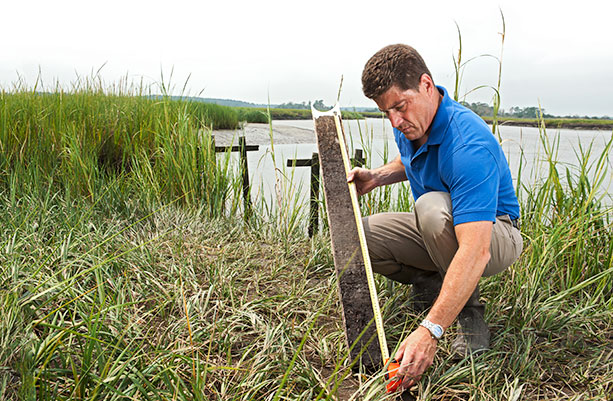
Christopher Sommerfield examines a core sample, a vertical record of marsh growth.
How old are the soils? See the image at upper-left.
