

Their efforts are part of the South River Science Team, a group formed in 2000 that is focused on reducing mercury levels that remain elevated almost 60 years after a former DuPont plant in Waynesboro stopped using the substance in its industrial processes. The team involves representatives from government agencies, nonprofits, universities, citizens groups and DuPont.
“They [DuPont] were very careful about [using mercury] but being careful now and in 1950, there's a difference,” said Pizzuto, professor of geology, explaining that the company used the substance from 1929 to 1950.
There wasn't a known problem until 1976, when elevated mercury levels were found in the river's fish. By that time, scientists knew that although mercury occurs naturally in the environment, high levels of exposure are harmful. According to the National Wildlife Federation, mercury can cause neurological and reproductive problems in animals, and it especially can affect larger and older animals, which accumulate the pollutant in their muscle tissue as they consume contaminated prey. In humans, the substance also can harm the central nervous system and cause birth defects.
Researchers began monitoring the area for mercury in 1984, though at that time they thought concentrations of the pollutant in the tissues of fish would decrease naturally.
That hasn't been the case.
South River Science Team members say an ongoing source of the contaminant is fueling the problem. Because previous samplings have shown elevated mercury levels in the soil in the river valley, they have good reason to believe the riverbank is the source.
When the river would overflow its banks decades ago, it piled contaminated sediments on the valley floodplain, Pizzuto said. Now, the river is eroding into those deposits and scientists suspect that contaminated sediment is re-entering the water.
The team wants to locate the places with the highest erosion rates and the greatest mercury concentrations so it can focus on those spots to stop contamination of the water. Researchers later this year will begin taking thousands of soil samples to pinpoint the locations with the most mercury.
As for the river's erosion rates, that's where Pizzuto and O'Neal come in.
They've used historical aerial photos to learn about the river's previous erosion rates. To determine the river's behavior now, they're applying a laser technology called LIDAR (Light Detection And Ranging) that's new to this kind of research.
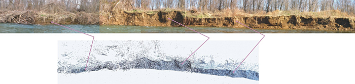
LIDAR works when a scientist aims a laser beam at the riverbank. Anything that reflects the laser's light is picked up by the instrument, which measures the distance to each object. When the survey data are plotted as dots, the result is a comprehensive three-dimensional model of the area. The technology, which is run by a computer, is especially useful because it can survey large sections of the riverbank in remarkable detail.
“Every leaf on the riverbank is picked up,” said O'Neal, assistant professor of geography. “When we survey a bank that's 1-meter tall and 50-meters long, we get between half a million and a million points representing anything that reflects the laser's light.”
Even though LIDAR technology has been around for about 20 years (experts have used it in other disciplines, especially engineering, and O'Neal has used it to study things like beach erosion and even an archeological site), the experts say this is the first time it has been used on a river.
The detail it provides is a contrast to the previous method used to survey riverbanks--pounding steel rods into the soil and measuring their movement through time. Pizzuto calls the new approach, which can yield several million measurements in just half an hour, “absolutely groundbreaking.”
“Low precision methods have been useful but don't allow you to get an idea of what's happening on the whole bank,” he said. “We tend to pick one or two places and see how it represents the whole thing. I think we're finding out we don't have a clue (with low-precision methods).”
Pizzuto, O'Neal and their students currently are gathering data with the LIDAR system from various spots in the 25 miles between Waynesboro and Port Republic, Va. With the help of Global Positioning System (GPS) receivers, they get location information about each of those points.
With each trip south, they get a little closer to understanding the river's behavior, and, they hope, solving a decades-old environmental problem.
Article by Elizabeth Boyle