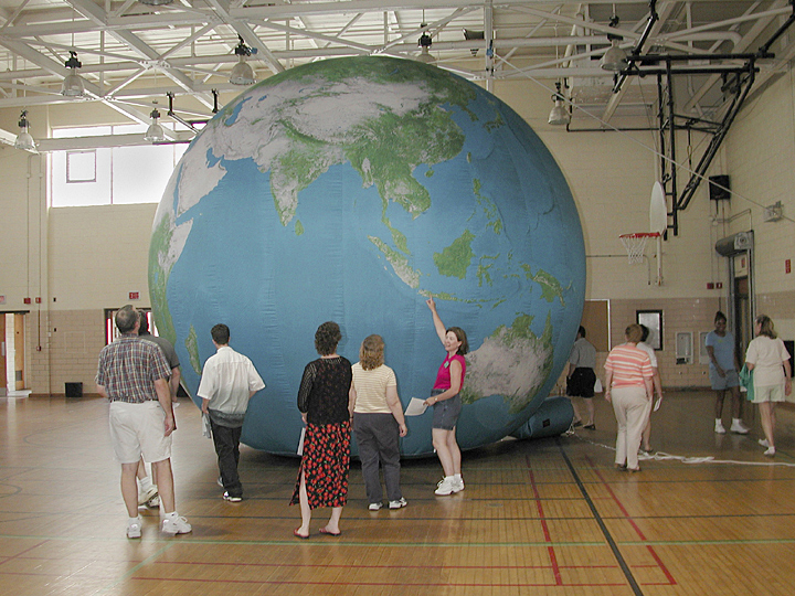
4:10 p.m., June 27, 2003--This past week, a group of Delaware teachers enrolled in the Geography Institute for Teachers, watched the world unfold before their eyes. A sailcloth Earth globe, divided into 24 panels, each representing a time zone, lay on the floor of the Pearson Hall Gymnasium, then was attached to a fan and in a matter of minutes was inflated to 19 feet in diameter.
 |
| Geography Institute for Teachers participants get a close-up look at the inflatable globe, which is 19 feet in diameter. |
Standing close to the globe, only the Southern Hemisphere is visible because of the globe’s size, but stepping into the globe onto Antarctica, via a large zipper on the international dateline, reveals the whole world from the inside out in mirror image. Major cities are identified, and using satellite imagery, sea and land areas are designated with blues for water, shades of green for forestation and light browns for coast and desert. The scale is 1 inch per 30 miles, and airplanes would fly approximately a quarter of an inch over the surface.
The Earth globe, part of the proposed Delaware Children’s Museum’s outreach program, is available for school use and is adaptable for teaching different age levels, according to Darlene Bailey, the facilitator of the museum project.
The Earth globe was just one of many activities the teachers took part in during the institute, which is sponsored by Delaware Geographic Alliance, housed in UD’s geography department. The institute, which ran from June 17-27, is geared to the Delaware Geography Standards and featured lectures, demonstrations on how to use information and hands-on activities in the classrooms and on-site field trips throughout the state, according to MaryAnna Taylor, alliance project coordinator.
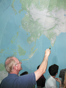 |
| Inside the globe, Peter Rees, associate professor of geography, (foreground) and others participants saw a mirror image of the Earth’s geography. |
Peter Rees, associate professor of geography, whose field is urban geography, also was on the institute staff and lectured and worked with the teachers. This year’s director was Mary Schoettinger, a fifth-grade teacher at Star Hill Elementary School in the Caesar Rodney School District.
The group investigated different geographical environments in all three counties of the state, Taylor said. Based at the Virden Center for part of the time, the teachers visited Cape Henlopen to learn how dunes were created and about changes in the coastline. They also studied the changing landscape of Sussex County, brought about by natural causes and human activities. Another field trip was to Trap Pond where the teachers boarded pontoon boats to learn about the cypress swamp.
In Kent County, the group visited Pickering Beach to study horseshoe crabs and then transected the county to visit the Amish country and big housing developments—a study in contrasts, Taylor said.
New Castle County field trips involved the rivers and the historically disputed corner where Delaware, Pennsylvania and Maryland meet.
The teachers share what they have learned with their colleagues at their home schools and also write lesson plans, which become part of the alliance’s collection and are available to teachers throughout the state. The alliance also offers geography workshops during the year.
The teachers gave the institute high marks.
Mary Matthes, a third-grade teacher from Rehoboth Elementary School, said that she learned many methods of integrating geography with other subjects in her classroom to meet the state standards. A Delaware native, she said she saw and learned much about the state that was new to her.
Tonya Mackey of Dover Central Middle School said the institute offered her many resources and lesson plans for her students, including the use of Internet sites. Educated in Florida before coming to Delaware eight years ago, she said the institute gave her an opportunity to discover much about her adopted state.
The Delaware Geographic Alliance, which is funded by the Delaware Department of Education, is an affiliate of the National Geographic Society, a network of alliances in all 50 states, Washington, D.C., Puerto Rico and Canada.
Article by Sue Moncure
Photos by Kevin Quinlan
|