


Aerial drone data
UD professor uses aerial drone to survey Adriatic coast following crippling nor'easter


3:25 p.m., March 6, 2015--Last month, a crippling February nor’easter brought sustained Bora winds of 50 miles per hour, and gusts of up to 60-70 miles per hour, to the Adriatic coast near Ferrara, Italy, creating devastating waves and storm surge.
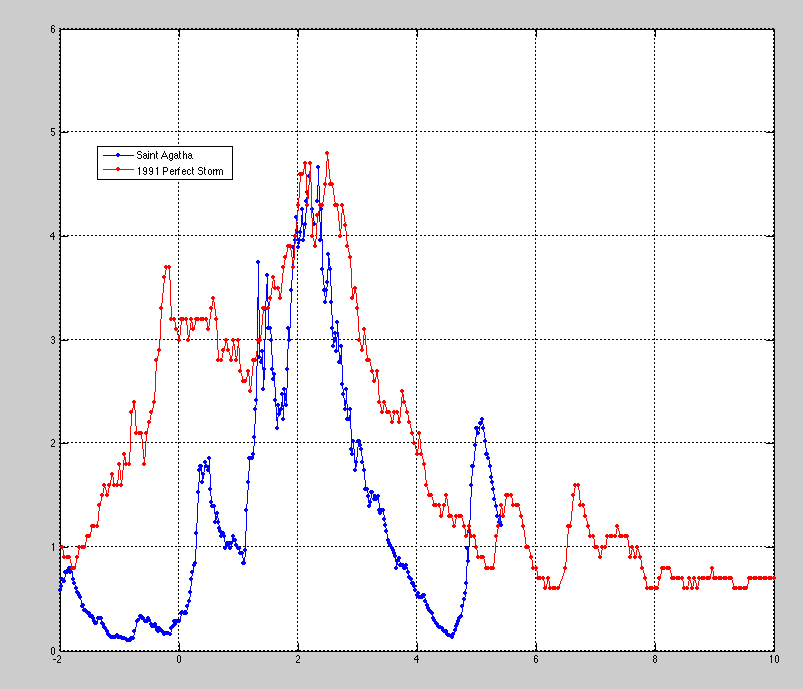
The storm’s massive size and strength was beyond anything recently recorded in Italy. Fifteen-foot waves similar to those generated by the Oct. 31, 1991, Halloween storm, known as “The Perfect Storm,” and sea level elevations approaching 4 feet above normal, battered the coast and caused widespread inland flooding. (For a graph depicting the wave height comparison of the two storms in meters, click here.)
Global Stories
Fulbright awards
Peace Corps plans
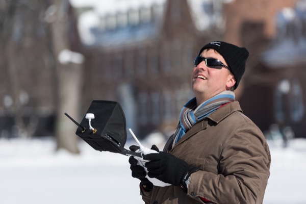
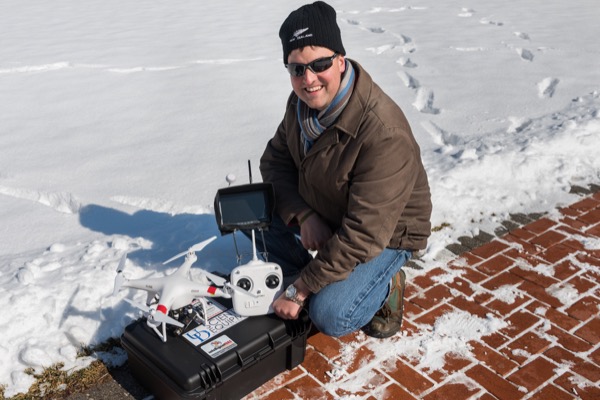
The University of Delaware’s Art Trembanis and colleagues at University of Ferrara (UF) were part of a rapid response team that used an unmanned aerial vehicle (UAV) from the College of Earth, Ocean, and Environment’s Robotic Discovery Laboratory to capture critical post-storm data along the Adriatic coast.
“We were able to provide a useful eye in the sky for researchers and local authorities engaged in response to this natural disaster, and also to collect unique and unprecedented quantitative measurements of the storm inundation and erosion,” said Trembanis, an associate professor of oceanography in the School of Marine Science and Policy.
The UAV is one of the newest technologies from CEOE’s Robotic Discovery Laboratory. Equipped with sensors, a high-definition camera and GPS technology, the aerial drone — also known as a quadcopter — can be deployed by a single operator and can capture high-resolution images and video during missions of up to 20 minutes long and travel distances of nearly 1,000 feet.
In Ferrara, one flight with the quadcopter generated an elevation model with over 58 million points and a resolution of approximately 1 inch per pixel. The resulting images were so detailed that researchers were able to recognize individual seashells and footprints captured by the UAV from a height of over 150 feet above the ground.
“These new robotic platforms provide scientists access to places that are dirty, dangerous, daring and dull – in this case daring and dangerous— in ways that would otherwise be expensive and time consuming,” Trembanis said. “They also provide a very powerful learning tool for showing students the risks and vulnerabilities of the shoreline.”
Trembanis and his colleagues are using the aerial images to generate three-dimensional maps and elevation models of the beaches, geomorphic data that will help the researchers answer important questions about how much sand was eroded, where it was deposited and where inundation lines varied. It also will provide details about how specific areas were affected comparatively, such as areas with and without dunes and developed and undeveloped areas.
The work is part of an ongoing project by his University of Ferrara colleagues, led by Paolo Ciavola, UF associate professor of physics and earth sciences. With funding from the European Union, the group is studying storm risk to model and reduce risks associated with coastal erosion and flooding.
“Now we have immediate post-storm data to compare to aerial LIDAR survey data from fall 2014. Over the next few months to years we will be looking at the recovery and the changes that ensue over time,” Trembanis said.
Connection to Delaware’s most devastating storm
Trembanis explained that the Adriatic Sea is a narrow body of water, similar to the Delaware Bay, with portions of the coast held as natural reserves and other areas developed in ways similar to Dewey Beach or Rehoboth Beach.
“It is being called the Saint Agatha storm and for impact in this region, in many ways this Adriatic storm’s impact is similar to what the 1962 Ash Wednesday storm was for Delaware – a strong and long lasting nor’easter,” he said.
Delaware’s devastating 1962 nor’easter, which occurred 53 years ago this week on March 5-6, caused unprecedented destruction to life and property. In Delaware alone, private and public property damage estimates exceeded $70 million, equivalent to approximately $547 million in 2014.
The 1962 Ash Wednesday storm is chronicled in a 2014 book written by local coastal storm experts including Wendy Carey of Delaware Sea Grant. The book includes over 200 vintage photographs, which along with the story carry a strong message about hazards, risks and the vulnerability of Delaware's communities and environments.
In Delaware, planned uses for the UAVs include coastal and marsh research on the Delmarva Peninsula. The top-down view of coastal areas will provide new insights into habitat growth and decay as well as offer new territory for image analysis research.
“It’s such a stable platform that you can imagine having the UAV hover over a spot for 10-15 minutes, maybe over a tidal cycle, to look at habitat interactions or how the water level changes, or maybe even things we haven’t even yet considered,” Trembanis said.
About the professor
Art Trembanis, who joined UD in 2005, is an associate professor of oceanography in the College of Earth, Ocean, and Environment’s School of Marine Science and Policy, with a joint appointment in the Department of Geological Sciences.
Trembanis has a background in coastal geomorphology, the study of how waves and currents shape the beach and seabed, and he is an expert in beach nourishment, sediment transport and scour (erosion) and seafloor mapping.
He was an early adopter of using autonomous underwater vehicles (AUVs) to explore the sea and examine what lies on the ocean floor and has developed several autonomous underwater robotic technologies and data visualization techniques.
Article by Karen B. Roberts
Photos by Evan Krape