


Thermal infrared imagery
UD professor uses thermal infrared imagery to remotely survey Delaware marshes


11:56 a.m., Feb. 11, 2015--University of Delaware researcher Jack Puleo reports a new method to remotely survey tidal mudflats in the IEEE journal Selected Topics in Applied Earth Observations and Remote Sensing.
The paper, titled “Quantifying Tidal Mud Flat Elevations from Fixed-Platform Long-Wave Infrared Imagery,” details how to collect elevation data in soft environments, such as a marsh, using infrared imagery instead of traditional surveying methods by water craft, walking or land vehicle.
Research Stories


Chronic wounds
Prof. Heck's legacy
The approach uses long-wave infrared imagery, relying on emitted radiance to delineate between an exposed mud flat and the water’s edge. Researchers identify the waterline via sharp gradients in image intensity, and test the method against a global positioning system (GPS) survey.
The result is estimates of tidal-flat elevations that are accurate to within two centimeters of the ground truth elevations obtained using a sled-mounted global positioning survey system.
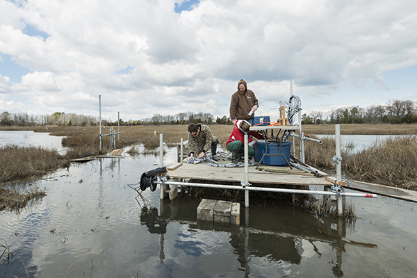
“Instead of putting a GPS sensor on the flat itself, we placed a remote sensing camera in a known location, with a known orientation, and let it ‘stare’ at the water coming into the channel and spilling onto the tidal flat,” said Puleo, an associate professor and coastal engineer in UD’s Department of Civil and Environmental Engineering and Center for Applied Coastal Research with a secondary appointment in the College of Earth, Ocean, and Environment and the paper’s lead author.
“This allowed us to infer the elevations across the mudflat from a mathematical standpoint and, at the same time, use the thermal imaging camera to create an elevation contour by sensing differences in temperature at the water’s edge.”
Co-authors include Thomas McKenna, a hydrogeologist with the Delaware Geological Survey and associate professor in the College of Earth, Ocean, and Environment, and Aline Pieterse, a graduate research assistant in the Department of Geological Sciences.
Puleo explained that this has long been accomplished using satellite imagery in the thermal and visible bands. However, water line edges often cannot be delineated in marsh environments where the muddy water and mud flat look the same. In addition, satellite imagery does not provide the spatial nor temporal resolution necessary to characterize small tidal mud flats. The fixed-platform approach is ideal for short-term deployments to quantify surface elevations over these soft environments.
Upon validating the results, the team determined that most of the error is confined to the edges of the channel, proving that the approach can be used to survey areas that are difficult to access.
“We’ve taken something we’re good at – image analysis – combined it with thermal imagery and applied it using a known technique not previously used in tidal wetlands. Our results show that the approach can be used in environments where traditional surveying is difficult,” said Puleo.
This tidal wetland study in Brockonbridge Marsh in Kent County, Delaware, revealed that the smaller channels in the marsh become active right when the fluid drains off the platform and into the channels. This causes a spike in velocity, turbulence and sediment concentrations.
“Once the channel is no longer connected to the platform via water, the channels become dynamic. This tells us that the majority of sediment transport may only happen for short time frames during the tidal cycle. The rest of the time, not much is going on. This is important when trying to generate a model on how a marsh responds, because it suggests all the action may be happening over small portions of the tide,” he said.
Lewes study looks at marsh sustainability
Through funding from Delaware Sea Grant, Puleo and his colleagues are applying this same infrared imagery technology to study a Lewes marsh along Gills Neck Road.
According to Puleo, in the 1930s and ’40s it was common practice to dig ditches into the marsh landscape along the Delaware coast as a form of mosquito control.
“The idea was that if saltwater flooded the marsh, it would be less likely to have mosquitos, since most cannot breed in salty water,” Puleo said.
The approach, now obsolete, didn’t work as intended but the ditches remain. Puleo’s team is studying how the manmade ditches, or channel networks, affect sediment movement and circulation in the marsh, important considerations for sustainability.
Marshes, he said, develop naturally as sediment is deposited, and grasses build on the sediment as the marsh tries to sustain itself to keep ahead of sea level rise. Infrastructure, such as homes and buildings, can interfere with this natural process.
During fieldwork at the Gills Neck Road site, the team placed over 50 sensors and tide gages in multiple channels to measure the velocity of the water during incoming and outgoing tides over an 18-day period. Some of the sensors took measurements as fast as 100 times per second, creating a lot of data. The next stage of the project includes analyzing the data and comparing it to other information, like the Brockonbridge Marsh data set.
“We hope to learn more about the physics that drive fluid and sediment through these manmade channels, as opposed to natural channels, and how that sediment exchange affects the natural environment,” Puleo said.
Article by Karen B. Roberts
Photo by Evan Krape