


Newark tornado
UD-based environmental monitoring system helped track storm conditions


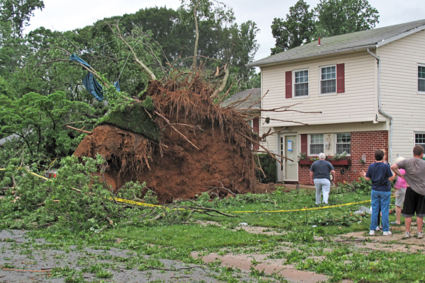
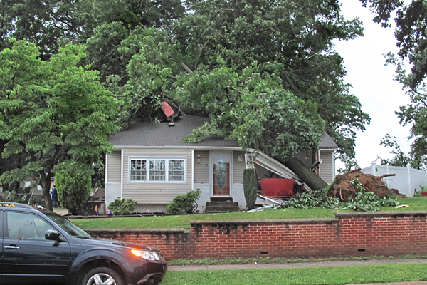
4:26 p.m., June 11, 2013--The tornado that downed trees and damaged homes in Newark on Monday evening, June 10, was uncommon but not unprecedented, according to Delaware State Climatologist Daniel Leathers, who is also a professor of geography in the University of Delaware’s College of Earth, Ocean, and Environment.
“It’s unusual for us to get a tornado in Delaware,” Leathers said. “It’s not like we get a ton of them. But since about 1950, we have averaged about one per year.”
Campus Stories


From graduates, faculty
Doctoral hooding
The National Weather Service classified the tornado as the weakest category, EF0, which generates wind speeds of 65 to 85 mph, and in this case uprooted trees, broke branches and damaged structures. The tornado struck the Robscott Manor neighborhood, near the southern edge of UD’s South Campus.
The Delaware Environmental Observing System (DEOS), based at UD, supplies information to the National Weather Service to monitor rainfall amounts and other aspects of storms as they move through Delaware.
Heavy rain over the past five days contributed to the damage. Delaware had 3.5 to 4 inches of rain on Friday, already saturating the ground before another 1.5 to 2.5 inches fell on Monday, Leathers said. The inundation loosened roots to make trees easier to topple and turned roads like Newark’s Main Street into small streams.
“There was just nowhere for the water to go,” Leathers said.
Associate State Climatologist Kevin Brinson observed trees that had the tops sheared off or mangled, cluing him in that the destruction was caused by a tornado and not straight-line winds.
Tornadoes often form when cool, dry air intersects with warm, moist air, which then rises rapidly. That was the type of situation on Monday when a low-pressure system and cold front in the Ohio Valley met warm, moist air locally, helping to set off thunderstorms and the tornado — although a small one.
“It was very small and it was also very weak,” Leathers said.
So small, in fact, that a DEOS weather station less than a half-mile from the tornado damage only picked up wind speeds of 20 miles per hour.
The peak season for tornadoes in Delaware is June through August, and they most often occur between 3 and 9 p.m. The state’s three counties are at nearly equal risk for being hit by tornadoes.
To learn more about how to prepare for tornadoes, hurricanes and other natural hazards, download a free copy of Delaware Sea Grant’s Delaware Homeowners Handbook to Prepare for Natural Hazards.
Article by Teresa Messmore
Photos by Tammy Beeson