ADVERTISEMENT
- Rozovsky wins prestigious NSF Early Career Award
- UD students meet alumni, experience 'closing bell' at NYSE
- Newark Police seek assistance in identifying suspects in robbery
- Rivlin says bipartisan budget action, stronger budget rules key to reversing debt
- Stink bugs shouldn't pose problem until late summer
- Gao to honor Placido Domingo in Washington performance
- Adopt-A-Highway project keeps Lewes road clean
- WVUD's Radiothon fundraiser runs April 1-10
- W.D. Snodgrass Symposium to honor Pulitzer winner
- New guide helps cancer patients manage symptoms
- UD in the News, March 25, 2011
- For the Record, March 25, 2011
- Public opinion expert discusses world views of U.S. in Global Agenda series
- Congressional delegation, dean laud Center for Community Research and Service program
- Center for Political Communication sets symposium on politics, entertainment
- Students work to raise funds, awareness of domestic violence
- Equestrian team wins regional championship in Western riding
- Markell, Harker stress importance of agriculture to Delaware's economy
- Carol A. Ammon MBA Case Competition winners announced
- Prof presents blood-clotting studies at Gordon Research Conference
- Sexual Assault Awareness Month events, programs announced
- Stay connected with Sea Grant, CEOE e-newsletter
- A message to UD regarding the tragedy in Japan
- More News >>
- March 31-May 14: REP stages Neil Simon's 'The Good Doctor'
- April 2: Newark plans annual 'wine and dine'
- April 5: Expert perspective on U.S. health care
- April 5: Comedian Ace Guillen to visit Scrounge
- April 6, May 4: School of Nursing sponsors research lecture series
- April 6-May 4: Confucius Institute presents Chinese Film Series on Wednesdays
- April 6: IPCC's Pachauri to discuss sustainable development in DENIN Dialogue Series
- April 7: 'WVUDstock' radiothon concert announced
- April 8: English Language Institute presents 'Arts in Translation'
- April 9: Green and Healthy Living Expo planned at The Bob
- April 9: Center for Political Communication to host Onion editor
- April 10: Alumni Easter Egg-stravaganza planned
- April 11: CDS session to focus on visual assistive technologies
- April 12: T.J. Stiles to speak at UDLA annual dinner
- April 15, 16: Annual UD push lawnmower tune-up scheduled
- April 15, 16: Master Players series presents iMusic 4, China Magpie
- April 15, 16: Delaware Symphony, UD chorus to perform Mahler work
- April 18: Former NFL Coach Bill Cowher featured in UD Speaks
- April 21-24: Sesame Street Live brings Elmo and friends to The Bob
- April 30: Save the date for Ag Day 2011 at UD
- April 30: Symposium to consider 'Frontiers at the Chemistry-Biology Interface'
- April 30-May 1: Relay for Life set at Delaware Field House
- May 4: Delaware Membrane Protein Symposium announced
- May 5: Northwestern University's Leon Keer to deliver Kerr lecture
- May 7: Women's volleyball team to host second annual Spring Fling
- Through May 3: SPPA announces speakers for 10th annual lecture series
- Through May 4: Global Agenda sees U.S. through others' eyes; World Bank president to speak
- Through May 4: 'Research on Race, Ethnicity, Culture' topic of series
- Through May 9: Black American Studies announces lecture series
- Through May 11: 'Challenges in Jewish Culture' lecture series announced
- Through May 11: Area Studies research featured in speaker series
- Through June 5: 'Andy Warhol: Behind the Camera' on view in Old College Gallery
- Through July 15: 'Bodyscapes' on view at Mechanical Hall Gallery
- More What's Happening >>
- UD calendar >>
- Middle States evaluation team on campus April 5
- Phipps named HR Liaison of the Quarter
- Senior wins iPad for participating in assessment study
- April 19: Procurement Services schedules information sessions
- UD Bookstore announces spring break hours
- HealthyU Wellness Program encourages employees to 'Step into Spring'
- April 8-29: Faculty roundtable series considers student engagement
- GRE is changing; learn more at April 15 info session
- April 30: UD Evening with Blue Rocks set for employees
- Morris Library to be open 24/7 during final exams
- More Campus FYI >>
12:48 p.m., Aug. 17, 2010----It's a process that begins 22,000 miles above our heads -- satellites collect information about our planet and transmit it back to Earth.
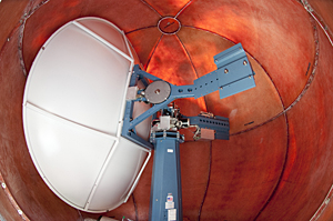
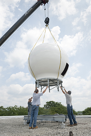
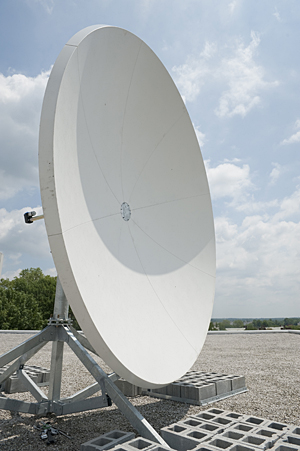
Thanks to two satellite receiving stations installed last month on the Newark campus, University of Delaware researchers will be among the few who can access that data as it streams in from space.
The equipment, located on the roof of the Willard Hall Education Building, benefits faculty and others who study changes in the mid-Atlantic environment. It will support a wide range of research projects, including ones that monitor coastal flooding; observe coastal waters for harmful algal blooms, which can deprive waters of oxygen; and track changes in ocean circulation that could be related to climate change.
One of the receivers provides information on land and ocean surface conditions such as sea-surface temperature, chlorophyll concentration, and currents, while the other focuses on atmospheric and weather changes such as tropical storm activity and temperatures.
“The two stations really complement each other because to understand what's happening in the atmosphere you need to know about what's happening at the surface of the earth and vice versa,” said Dan Leathers, professor of geography and deputy dean in the College of Earth, Ocean, and Environment (CEOE). “We have a lot of people in the college who are interested in interactions between the atmosphere and the land and ocean surface.”
Leathers, who led efforts to acquire the equipment, received support from a committee of CEOE faculty that included Xiao-Hai Yan, Mary A.S. Lighthipe Professor of Marine Studies; Matt Oliver, assistant professor of oceanography; Tracy DeLiberty, associate professor of geography, and Young-Heon Jo, assistant research professor of oceanography.
Supplied and installed by California-based SeaSpace Corp., the stations cost about $500,000. A National Oceanic and Atmospheric Administration (NOAA) grant obtained by CEOE Dean Nancy Targett funded them.
From their perch atop the Willard Hall Education Building -- chosen because it allows a 360-degree view of the horizon with no electromagnetic interference -- the receivers collect information on a large swath of the globe. They capture data on the middle of the Atlantic to the center of North America and from Cuba to Newfoundland.
The beauty of having such technology right on campus, said the scientists involved, is that it gives them access to real-time data. There are only a handful of the receiving stations on the east coast, and UD researchers previously had to depend on other organizations to obtain data.
“That meant a delay of hours or even days,” said Yan, who also directs UD's Center for Remote Sensing. “Now we can monitor our coast so we will know right away if there is anything we need to respond to, a significant weather event for example.”
UD researchers also plan to provide that information to others who can use it, including other university and government researchers as well as state government emergency response and monitoring agencies.
Educators at the K-12 level are also expected to make use of the information. The Delaware Geographic Alliance plans to work with teachers to create teaching models that rely on such data for lessons on topics like meteorology or ocean currents.
Another benefit of the technology is that it provides raw data directly from the satellites. The data that come from the satellites give the intensity of electromagnetic radiation at different frequencies or wavelengths, Leathers explained.
“What the researchers really will be doing is developing algorithms or formulas to pull a bunch of those different frequencies and put them together in a way that tells you something,” he said. “They want that raw data so they can come up with algorithms to figure out better ways to look at what's happening on the earth's surface.”
Helping facilitate the huge amount of data will be a new technician to be hired this summer. That position, also funded by the NOAA grant, is designed for someone who will be responsible for data storage and dissemination to users.
Article by Elizabeth Boyle
Photos by Evan Krape


