ADVERTISEMENT
- Rozovsky wins prestigious NSF Early Career Award
- UD students meet alumni, experience 'closing bell' at NYSE
- Newark Police seek assistance in identifying suspects in robbery
- Rivlin says bipartisan budget action, stronger budget rules key to reversing debt
- Stink bugs shouldn't pose problem until late summer
- Gao to honor Placido Domingo in Washington performance
- Adopt-A-Highway project keeps Lewes road clean
- WVUD's Radiothon fundraiser runs April 1-10
- W.D. Snodgrass Symposium to honor Pulitzer winner
- New guide helps cancer patients manage symptoms
- UD in the News, March 25, 2011
- For the Record, March 25, 2011
- Public opinion expert discusses world views of U.S. in Global Agenda series
- Congressional delegation, dean laud Center for Community Research and Service program
- Center for Political Communication sets symposium on politics, entertainment
- Students work to raise funds, awareness of domestic violence
- Equestrian team wins regional championship in Western riding
- Markell, Harker stress importance of agriculture to Delaware's economy
- Carol A. Ammon MBA Case Competition winners announced
- Prof presents blood-clotting studies at Gordon Research Conference
- Sexual Assault Awareness Month events, programs announced
- Stay connected with Sea Grant, CEOE e-newsletter
- A message to UD regarding the tragedy in Japan
- More News >>
- March 31-May 14: REP stages Neil Simon's 'The Good Doctor'
- April 2: Newark plans annual 'wine and dine'
- April 5: Expert perspective on U.S. health care
- April 5: Comedian Ace Guillen to visit Scrounge
- April 6, May 4: School of Nursing sponsors research lecture series
- April 6-May 4: Confucius Institute presents Chinese Film Series on Wednesdays
- April 6: IPCC's Pachauri to discuss sustainable development in DENIN Dialogue Series
- April 7: 'WVUDstock' radiothon concert announced
- April 8: English Language Institute presents 'Arts in Translation'
- April 9: Green and Healthy Living Expo planned at The Bob
- April 9: Center for Political Communication to host Onion editor
- April 10: Alumni Easter Egg-stravaganza planned
- April 11: CDS session to focus on visual assistive technologies
- April 12: T.J. Stiles to speak at UDLA annual dinner
- April 15, 16: Annual UD push lawnmower tune-up scheduled
- April 15, 16: Master Players series presents iMusic 4, China Magpie
- April 15, 16: Delaware Symphony, UD chorus to perform Mahler work
- April 18: Former NFL Coach Bill Cowher featured in UD Speaks
- April 21-24: Sesame Street Live brings Elmo and friends to The Bob
- April 30: Save the date for Ag Day 2011 at UD
- April 30: Symposium to consider 'Frontiers at the Chemistry-Biology Interface'
- April 30-May 1: Relay for Life set at Delaware Field House
- May 4: Delaware Membrane Protein Symposium announced
- May 5: Northwestern University's Leon Keer to deliver Kerr lecture
- May 7: Women's volleyball team to host second annual Spring Fling
- Through May 3: SPPA announces speakers for 10th annual lecture series
- Through May 4: Global Agenda sees U.S. through others' eyes; World Bank president to speak
- Through May 4: 'Research on Race, Ethnicity, Culture' topic of series
- Through May 9: Black American Studies announces lecture series
- Through May 11: 'Challenges in Jewish Culture' lecture series announced
- Through May 11: Area Studies research featured in speaker series
- Through June 5: 'Andy Warhol: Behind the Camera' on view in Old College Gallery
- Through July 15: 'Bodyscapes' on view at Mechanical Hall Gallery
- More What's Happening >>
- UD calendar >>
- Middle States evaluation team on campus April 5
- Phipps named HR Liaison of the Quarter
- Senior wins iPad for participating in assessment study
- April 19: Procurement Services schedules information sessions
- UD Bookstore announces spring break hours
- HealthyU Wellness Program encourages employees to 'Step into Spring'
- April 8-29: Faculty roundtable series considers student engagement
- GRE is changing; learn more at April 15 info session
- April 30: UD Evening with Blue Rocks set for employees
- Morris Library to be open 24/7 during final exams
- More Campus FYI >>
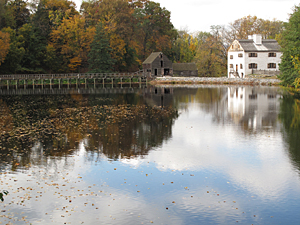
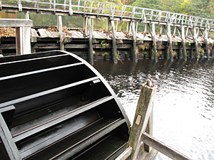
9:03 a.m., Nov. 13, 2009----It's a picturesque early American image -- a gristmill complete with a water wheel perched on the banks of a swiftly flowing river or stream. Many of these mills are long gone today, but scientists are discovering that the dams associated with them can have lasting environmental effects.
The University of Delaware's Jim Pizzuto and Michael O'Neal have documented those effects in Virginia, where they've been working to decrease the amount of mercury entering the South River. The College of Earth, Ocean, and Environment (CEOE) scientists are part of an interdisciplinary team that's trying to understand how mercury is still getting into the river even though a nearby former DuPont plant known to have caused the contamination stopped using the substance in 1950. The pair's research, published in Geology earlier this year, concluded that one of the mercury sources is related to milldams.
“The dams may have played a role in trapping the mercury and their demise is key to getting it back into the river,” said Pizzuto, professor of geology.
Historical documents show that about 14 dams were built during the first half of the 20th century in the 18-mile stretch between Waynesboro and Port Republic. The dams raised the water level upstream for power generation. Nearly all the dams in that 18-mile stretch were breached by the mid-20th century, increasing river flow and erosion rates in those areas.
Because the South River's clay and silt is contaminated with mercury, increased erosion means the toxic chemical is redistributed into the water.
Pizzuto and O'Neal's research, which also garnered an article in Earth magazine, published by the American Geological Institute, involved surveying historical documents and aerial photos to better understand erosion rates as well as talking with area residents to learn when the breaches occurred.
Today the researchers are working to figure out exactly where the most erosion is occurring and at what rates so they can find and remediate the main mercury sources. They plan to develop a conceptual model of how the river responded when the dams were breached in order to predict which sites are most susceptible to erosion.
“We think that some of these rates are going to be highest in some of the places where the old dams used to be,” said Pizzuto, who teamed up with O'Neal, assistant professor of geography, in 2005 to research the mercury problem.
Their findings don't impact the South River project alone, however. In 2008 colleagues of theirs published an article in Science documenting hundreds of thousands of milldams in the Mid-Atlantic. The authors argue that much of the behavior of rivers today is influenced by old dams, now disappeared. The research challenges standing beliefs, especially related to the multi-billion-dollar industry of river restoration.
“They claim that most of the contaminants and sediment that are reaching the Chesapeake Bay are not coming from farm fields, as previously thought, but in fact are caused by the erosion of these sediments trapped behind dams,” Pizzuto said. “But they didn't have data to show that. Our study points a finger in that direction pretty strongly.”


