- Rozovsky wins prestigious NSF Early Career Award
- UD students meet alumni, experience 'closing bell' at NYSE
- Newark Police seek assistance in identifying suspects in robbery
- Rivlin says bipartisan budget action, stronger budget rules key to reversing debt
- Stink bugs shouldn't pose problem until late summer
- Gao to honor Placido Domingo in Washington performance
- Adopt-A-Highway project keeps Lewes road clean
- WVUD's Radiothon fundraiser runs April 1-10
- W.D. Snodgrass Symposium to honor Pulitzer winner
- New guide helps cancer patients manage symptoms
- UD in the News, March 25, 2011
- For the Record, March 25, 2011
- Public opinion expert discusses world views of U.S. in Global Agenda series
- Congressional delegation, dean laud Center for Community Research and Service program
- Center for Political Communication sets symposium on politics, entertainment
- Students work to raise funds, awareness of domestic violence
- Equestrian team wins regional championship in Western riding
- Markell, Harker stress importance of agriculture to Delaware's economy
- Carol A. Ammon MBA Case Competition winners announced
- Prof presents blood-clotting studies at Gordon Research Conference
- Sexual Assault Awareness Month events, programs announced
- Stay connected with Sea Grant, CEOE e-newsletter
- A message to UD regarding the tragedy in Japan
- More News >>
- March 31-May 14: REP stages Neil Simon's 'The Good Doctor'
- April 2: Newark plans annual 'wine and dine'
- April 5: Expert perspective on U.S. health care
- April 5: Comedian Ace Guillen to visit Scrounge
- April 6, May 4: School of Nursing sponsors research lecture series
- April 6-May 4: Confucius Institute presents Chinese Film Series on Wednesdays
- April 6: IPCC's Pachauri to discuss sustainable development in DENIN Dialogue Series
- April 7: 'WVUDstock' radiothon concert announced
- April 8: English Language Institute presents 'Arts in Translation'
- April 9: Green and Healthy Living Expo planned at The Bob
- April 9: Center for Political Communication to host Onion editor
- April 10: Alumni Easter Egg-stravaganza planned
- April 11: CDS session to focus on visual assistive technologies
- April 12: T.J. Stiles to speak at UDLA annual dinner
- April 15, 16: Annual UD push lawnmower tune-up scheduled
- April 15, 16: Master Players series presents iMusic 4, China Magpie
- April 15, 16: Delaware Symphony, UD chorus to perform Mahler work
- April 18: Former NFL Coach Bill Cowher featured in UD Speaks
- April 21-24: Sesame Street Live brings Elmo and friends to The Bob
- April 30: Save the date for Ag Day 2011 at UD
- April 30: Symposium to consider 'Frontiers at the Chemistry-Biology Interface'
- April 30-May 1: Relay for Life set at Delaware Field House
- May 4: Delaware Membrane Protein Symposium announced
- May 5: Northwestern University's Leon Keer to deliver Kerr lecture
- May 7: Women's volleyball team to host second annual Spring Fling
- Through May 3: SPPA announces speakers for 10th annual lecture series
- Through May 4: Global Agenda sees U.S. through others' eyes; World Bank president to speak
- Through May 4: 'Research on Race, Ethnicity, Culture' topic of series
- Through May 9: Black American Studies announces lecture series
- Through May 11: 'Challenges in Jewish Culture' lecture series announced
- Through May 11: Area Studies research featured in speaker series
- Through June 5: 'Andy Warhol: Behind the Camera' on view in Old College Gallery
- Through July 15: 'Bodyscapes' on view at Mechanical Hall Gallery
- More What's Happening >>
- UD calendar >>
- Middle States evaluation team on campus April 5
- Phipps named HR Liaison of the Quarter
- Senior wins iPad for participating in assessment study
- April 19: Procurement Services schedules information sessions
- UD Bookstore announces spring break hours
- HealthyU Wellness Program encourages employees to 'Step into Spring'
- April 8-29: Faculty roundtable series considers student engagement
- GRE is changing; learn more at April 15 info session
- April 30: UD Evening with Blue Rocks set for employees
- Morris Library to be open 24/7 during final exams
- More Campus FYI >>
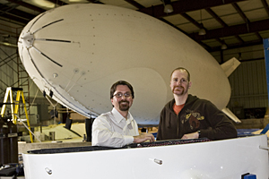
8:25 a.m., Jan. 22, 2009----Thanks to a generous donation from alumna Rachel Jewett Ledbetter, the University of Delaware has acquired a non-rigid airship, better known as a blimp, that will be used as an environmental research and monitoring platform for a myriad of research and education applications. Ledbetter graduated from UD in 1944 with a degree in chemistry.
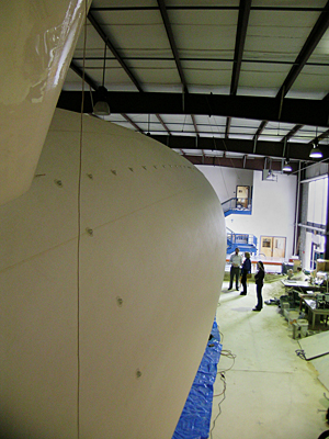
The University community was invited to view the airship, known as the Low-Altitude Environmental Analysis Dirigible (LEAD) for the first time on Tuesday, Jan. 14, in its temporary home in the Center for Applied Coastal Research. An official unveiling and dedication will take place later this spring.
Believed to be the first of its kind in a university setting, the UD blimp project crosses three colleges and is expected to impact thousands of students taking more than 50 courses, ranging from Geographic Information Science, Coastal Field Biology, Geological Oceanography, and Population Ecology to Meteorology, Surveying, Hydrology, and Microclimatology.
The brainchild of Michael A. O'Neal, assistant professor of geography, the 60-foot long blimp operates via remote control at altitudes of up to 500 meters with instrument payloads of up to 100 pounds. It has an interchangeable payload design, enabling it to be equipped with a variety of imaging instrumentation, including a laser scanner and visible, ultraviolet, and infrared cameras.
“Much of what we do in classroom settings attempts to utilize data made publicly available by other institutions or agencies,” O'Neal says. “LEAD transforms learning in the classroom by not restricting students to such data, but instead allowing them to choose the type, extent, and resolution of data collected for their particular need -- an unprecedented goal for any University.”
Depending on the instrumentation used, researchers will be able to capture data and analyze land-use and land-cover change, geomorphology, climate variability, coastal processes, landfill chemistry, and a broad variety of other environmental phenomena.
“The blimp will offer us a wonderful opportunity to fly over large sections of the coast every six months or so and note changes, at a much lower cost than renting a small plane each time,” says Jack Puleo, assistant professor of civil engineering.
One of Puleo's interests lies in using LIDAR (Light Detection and Ranging) equipment to generate topographic maps of Delaware's coastline so that he can assess dune height variability and beach erosion.
Manufactured by Galaxy Blimps in Dallas, the airship underwent test runs filming sports events before the University of Delaware purchased it. However, the new high-definition television equipment used in the broadcasting industry proved too heavy for the blimp, so it was recommissioned by UD as a “research vessel.”
While research using the airship will begin soon with funding from Kent County and the University of Delaware Research Foundation (UDRF), it is not quite ready for prime time. The blimp has yet to be adorned with a decorative “skin” that will honor Mrs. Ledbetter's grandfather, Thomas Tustin Cloward, while also showing its UD affiliation.
In addition to the purchase of the blimp itself, which was enabled by Mrs. Ledbetter's donation, the colleges of Arts and Sciences, Engineering, and Marine and Earth Studies provided funds for accessories, including the 20-foot trailer used to transport the blimp when it is deflated.
According to Puleo, the initial seed grants from Kent County, UDRF, and others will enable the feasibility of the technology to be demonstrated. “This will give us the potential to attract large grants from agencies like the Office of Naval Research,” he says.
“The use of this tool in the university setting is limited only by the types of instrumentation that students and faculty can envision,” O'Neal says. “The project was launched in a true interdisciplinary spirit, and we're happy to have the larger research community seeking new uses for it.”
Article by Diane Kukich


