|
|
|
|
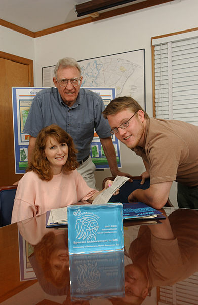
Water Resources Agency recognized for GIS analysis
Vern Svatos, a GIS manager at UD, and Jarrod Doucette, a GIS analyst, were chosen for their work in the use of GIS to help the Delaware Rural Housing Consortium (DRHC), a group of seven nonprofit housing developers. Their analysis aided the DRHC in locating areas that might be suitable for the construction of affordable housing in Kent and Sussex counties. Nicole Minni, a graphics artist and GIS specialist for the agency, created the maps for the study. Using GIS software on their computers, housing planners can view different building scenarios and focus on different factors how close a lot is to sewer lines, how expensive particular lots are or how close lots are to populations that need low-income housing. The results can be viewed spatially, in map form. The focus of the data can be modified and the analysis can be run again to gauge the effect of that modification. “When they saw the maps, a lot of people had what I would call a V-8 moment - Wow! Why didn’t we think of that site!’’ Mark Kleinschmidt, president of MAK Associates in New Castle, who worked with the agency to make the housing maps, said. The agency presented information on maps that once would have existed only in lists—census data on the areas where residents make less than $35,000, the age of the area housing stock, recent developments, the number of rental units, proximity to water-service areas and proximity to town boundaries. The agency took these types of data compiled in list form and used a GIS to manipulate them and show the results spatially in a way that wasn’t previously possible without the use of a GIS. “Hopefully, this may have a positive influence on some people’s lives, and I feel good about that,’’ Svatos said. “It’s one thing to create a map that shows spatially what exists. But, with a GIS, one can take a number of disparate data sets, analyze their cumulative effects and display the results spatially. In a sense, it shows what could exist.” UD’s Water Resources Agency has been using GIS for more than 25 years. Besides their award-winning work for DRHC, Svatos and his team have implemented a GIS for the Delaware River Basin Commission in Trenton, N.J.; created a GIS data set of schools for the state Department of Education; created more than 20 maps to support the work of Jerry Kauffman, the agency’s project director, in the development of a strategy to address water quality problems in the Christina River Basin; and created hundreds of maps for use by the Institute for Public Administration’s Planning Services Group, headed by Martin Wollaston, as they develop comprehensive land use plans for Delaware’s towns. For more information, visit [http://www.esri.com/sag/index.html]. Photo by Duane Perry To learn how to subscribe to UDaily, click here. |