 |
March 3, 2003--Combining an interest in the classics with expertise in the sedimentary geology that defines coastlines, a University of Delaware researcher has discovered that Homer’s “Iliad” presents an accurate account of the geography of ancient Troy.
John C. Kraft, H. Fletcher Brown Professor of Geology, said that scholars have debated the true location of Troy for about 2,000 years, with many casting doubt on the accounts of both Homer and the first century Greek geographer Strabo, who commented extensively on the Homeric descriptions in his own work.
However, Kraft writes in the February 2003 issue of the journal Geology, which is published by the Geological Society of America, that the area’s sedimentology and geomorphology do indeed complement the features described in Homer’s “Iliad.”
An epic poem and a classic of world literature, the “Iliad” recounts portions of the war between Greece and the city-state of Troy.
“The reality of Homer’s description of place, event and topography correlated with geologic investigation helps show that the ‘Iliad’ is not just a legend but regularly consistent with paleogeograhic reconstruction,” concluded the research team, which also included George Rapp of the University of Minnesota, Ilhan Kayan of Ege University in Izmir, Turkey, and classical scholar John V. Luce of Trinity College in Dublin, Ireland.
Kraft has been studying the ancient coastlines of the eastern Mediterranean Sea for more than two decades and has always been interested in the classics, and particularly in their descriptions of geography. However, three years ago he met Luce, a noted classicist who Kraft said “understands the ‘Iliad’ backwards and forwards.”
“I asked him if in his reading he had encountered incidents that indicated in any way topography,” Kraft said.
After discussions of the basics of geography and geology as related to archaeological settings, Luce began to uncover “dozens and dozens of such incidents,” Kraft said.
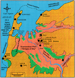
Kraft said archaeologists working around Hissarlik in western Turkey have found evidence of a city of the right age to be Troy. One problem with pinpointing the exact location of the Greek camp in relation to the city is that the landscape has changed drastically over thousands of years because of siltation caused by the Scamander (now called the Kara Menderes) and Simois (Dumrek) rivers.
Researchers now know that Troy once stood alongside a large bay, a portion of which was already filled by silt by the time of Homer, Kraft said, adding that today the bay is completely filled.
Using borings to determine the geomorphic environment, the researchers were able to develop maps of the changing coastline and found that the landscape at the time of the Homeric account of the Trojan War, about 1250 B.C., does indeed match descriptions in the “Iliad” and in Strabo’s later “Geography.”
 |
| John C. Kraft, H. Fletcher Brown Professor of Geology |
It appears that from the epic tale Strabo correctly calculated at about four kilometers the distance of Troy from the camp and ship station manned by the invading Greeks. He also spoke of blind mouth marshes and saltwater lagoons and marshes, which Kraft said are “very precise determinants of the shape of the coastline and ancient landscape at the time of the ‘Iliad.’”
From the “Iliad” itself, Kraft’s paper notes several descriptions, including the terrain covered by the line of defense established by the Trojans and their allies as described to the Greeks by the captured Trojan spy Dolon.
“I will answer your questions truly and exactly. On the wings towards the sea are Carians, Paionians with their crooked bows, Leleges, Kaukones and devine Pelasgians. On the wing towards Thymbra lie Lycians, proud Mysians, and Phrygian and Maeonian charioteers,” Dolon said.
And from another passage, “Outside the town…there is a high mound…which men call Thorn Hill (Batieia)…It was here that the Trojans and their allies now formed up in battle order.”
Kraft said that shows the Trojan line of defense extended from the sea in front of Troy southeastward, covering the possibility that the Greeks would attack anywhere along the Scamander Plain.
He said it is apparent from the writings that the Greek camp and ship station were in clear sight of one another, and cited two passages that describe the encampment and the ship station:
“Whenever he looked toward the Trojan plain, he wondered at the many watch fires blazing before Ilios, at the sound of flutes and pipes, and at the murmuring from the host of men.”
And, “The ships had been beached on the shore of the surging sea well away from the fighting. They dragged the first ones inland and built a wall at their sterns. For the beach, though broad, could not contain all the ships, and the force was cramped. So they ranged them in rows, and filled as the long mouth of the shore between the enclosing headlands.”
Kraft noted that in antiquity, the Greek commentator Aristarchus compared the rows of beached ships to “seats in a theater” and “rungs on a ladder.”
The “Iliad” also describes the Kesik Cut, a great wall and ditch proposed by the ancient Greek warrior Nestor as a protective device “to hold back horses and fighting men so that the stout Trojan battle line may not overwhelm us.”
The poem describes how horses were “brought up short on the edge of the ditch and stand whinnying in fear, unable to jump it or pass over it.”
The section that tells of the battle at the Scamander Plain notes that when the Trojan line broke, many warriors “were pinned back against the deep stream with its silver eddies. In they tumbled with loud splashes, and the din resounded from the depths of the pools and from the banks on the other side. With piteous cries they swam here and there, whirled round by the current.”
Such a dramatic description of a deep river with cut banks and strong currents can only fit the middle and upper stretches of the Scamander Plain before Troy, Kraft said.
Given the vivid images painted by Homer, Kraft said he believes the author had seen the landscape firsthand. “Homer was certainly there, from the power of his descriptions,” Kraft said, laying aside speculation by some scholars that the poet was blind. “You can’t have really detailed descriptions of areas without having seen them.”
Kraft said the work has been both fun and enlightening.
He wanted to publish the findings, he said, because “maybe we should pay more attention to what is written.”
Kraft joined the UD faculty in 1964. He holds a bachelor’s degree in geology and mineralogy from the Pennsylvania State University and both a master’s in geology and sedimentology and a doctorate in geology and micropaleontology from the University of Minnesota.
Article by Neil Thomas
Photo by Robert Cohen
Illustration by John C. Kraft
|