
Three conservation landowners of the Milford Neck Wildlife area, The Delaware Division of Fish and Wildlife, Delaware Wild Lands, and The Nature Conservancy, are working collaboratively across jurisdictional boundaries to conserve the area’s biological resources and natural features. These land managers are particularly interested in managing habitat for estuarine fishes and water quality, migratory shorebirds, spawning horseshoe crabs, beach-nesting birds, waterfowl and wading birds, and forest interior dwelling birds.
The Problem
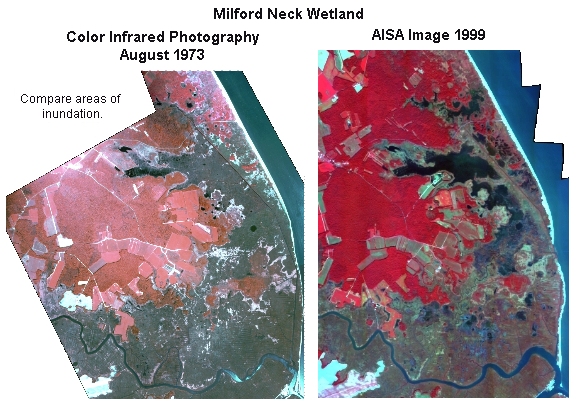
Recent changes in the shoreline and tidal marsh in the vicinity of Big Stone Beach have resulted in dramatic habitat conversion that will likely have significant immediate and long-term impacts on the biological resources and ecological integrity of the Milford Neck Conservation Area. The narrow barrier beach south of Big Stone Beach, which has been transgressing westward, was breached during the 1985-86 winter allowing direct exchange of tidal flow between Greco’s Canal and the Delaware Bay. Subsequently there has been the loss of more than 500 m of beach. A large area of tidal marsh northwest of the breach has become permanently inundated or converted into tidal flats. Aerial photography taken in August 1973 shows that only a small portion of the area was then inundated. Analysis of Thematic Mapper satellite imagery for the years 1984 and 1993 show that this area of open water and mud flats west of the canal has increased from about 40 ha to about 160 ha (with a corresponding loss of Spartina alterniflora marsh). Areas of open water in the tidal marsh areas east of the canal also have increased during this period. Vegetation bordering natural ponds within the marsh and near the interface of marsh and upland forest is reported to be shifting toward a less diverse, more halophytic (i.e., salt tolerant) community. The common reed (Phragmites australis) appears from satellite change analysis to have expanded in these areas. Delaware Division of Fish and Wildlife has undertaken a program of herbicidal spraying to control the plant on its land. The Nature Conservancy has identified Phragmites expansion as a problem on its land in the vicinity of Big Stone Beach. The Nature Conservancy has undertaken to reverse this expansion and restore some 150 ha of tidal wetland habitat.
A study was undertaken to document the contemporary tide conditions, the spatial distribution of open water and marsh habitat communities and especially the distribution of Phragmites to provide a base against which to measure future change. Whether the recent expansion of open water is going to continue as a trend or is likely be self limiting through increased sedimentation needs to be understood. Here we report on and evaluate an effort of mapping the habitat using a high spatial and spectral resolution airborne digital scanner.
Traditionally, aerial photography provided the best means of obtaining low cost high spatial resolution image data. Polygons of vegetation such as pure dense stands of Phragmites can be identified with reasonable accuracy at a minimum mapping unit of about one acre using stereo interpretation of color infra-red photography. However, low density canopies, small patches, and Phragmites mixed with other vegetation are often missed. It is not uncommon for Phragmites to be mapped at a minimum spatial resolution of several acres because of such difficulties in its recognition. Satellite sensing systems such as Thematic Mapper (TM) aboard the Landsat series of satellites have an advantage over photography in yielding image data over the spectral range 400 to 2500 nanometers, covering visible, near infrared and mid infrared wavelengths in six spectral bands. Although this spectral coverage facilitates distinguishing wetland from upland vegetation, the 30 m ground spatial resolution of the TM data is not sufficiently high for the present application. Further, the frequency with which data at a particular site can be obtained is limited by the probability of coincidence of favorable weather and atmospheric conditions with a twice a month satellite return interval. The airborne AVARIS hyperspectral remote sensing system operated by the Jet Propulsion Laboratory provides higher spatial resolution and very high radiometric resolution with the flexibility of aircraft to allow scheduling observations during favorable weather. However, cost is high.
A relatively low cost airborne hyperspectral imaging spectrometer, AISA, was recently developed for use in forestry and agricultural surveillance. This spectrometer is sensitive over the visible and near infrared wavelengths 450 to 850 nm. Experience with it in identifying health of agricultural crops in "precision agriculture" had suggested the high spectral resolution of the instrument could allow discrimination among wetland vegetation species. We employed it in this study to evaluate its potential for wetland mapping and in discriminating tidal wetland species of vegetation.